Oscano elevation
Oscano (Umbria, Provincia di Perugia), Italy elevation is 293 meters and Oscano elevation in feet is 961 ft above sea level [src 1]. Oscano is a populated place (feature code) with elevation that is 29 meters (95 ft) smaller than average city elevation in Italy.
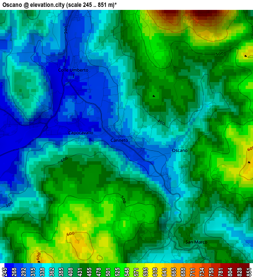
Below is the Elevation map of Oscano, which displays elevation range with different colors. Scale of the first map is from 245 to 851 m (804 to 2792 ft) with average elevation of 416.2 meters (=1365 ft) [note 1]
These maps also provides idea of topography and contour of this city, they are displayed at different zoom levels. More info about maps, scale and edge coordinates you can find below images.
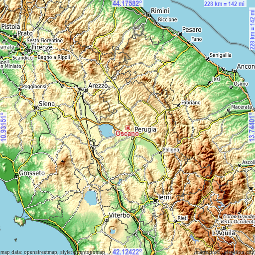
| \ | Map #1 | Topo.Map |
| Scale [m] | 245..851 m | × |
| Scale [ft] | 804..2792 ft | × |
| Average | 416.2 m = 1365 ft | × |
| Width | 7.13 km = 4.4 mi | 228.1 km = 141.7 mi |
| Height | 7.13 km = 4.4 mi | 228.1 km = 141.7 mi |
| ↑Max Latitude | 43.190678° | 44.17582° |
| Latitude at center | 43.15863° | 43.15863° |
| ↓Min Latitude | 43.126565° | 42.12422° |
| ← Min Longitude | 12.293815° | 10.93151° |
| Longitude center | 12.33776° | 12.33776° |
| →Max Longitude | 12.381705° | 13.74401° |
Nearby cities:
Cities around Oscano sort by population:
• Perugia elevation 482 m
6.6 km,  141°
141°
• Chiugiana-La Commenda 247 m
7.1 km,  199°
199°
• Magione 239 m
10.4 km,  259°
259°
• Ponte Felcino 203 m
9.6 km,  109°
109°
• Colombella 273 m
11.8 km,  93°
93°
• Mantignana 261 m
4 km,  272°
272°
• Ponte Pattoli 210 m
7.7 km,  73°
73°
• Pila 290 m
11.7 km,  183°
183°
• Casa del Diavolo 237 m
9.6 km, 70°
• Lacugnano 322 m
7.1 km, 184°
• Corciano 395 m
5.3 km,  230°
230°
• bishopric of Perugia 395 m
6.6 km, 140°
Multilingual:
 En español:
Oscano elevación 293 m.
 En France:
Oscano élévation 293 m.


Sources and notes:
- [note 1] Map square and city borders are not equal. Map elevation data is calculated only from area inside that square.
- [src 1] Elevation data from geonames database provided with same terms of usage.
- [src 2] The elevation map of Oscano is generated using elevation data from NASA's 3 arcsec (90m) resolution SRTM data.
- [src 3] Base (background) map © OpenStreetMap contributors tiles are generated by Geofabrik and OpenTopoMap.
Copyright & License:
This Oscano Elevation Map is licensed under CC BY-SA. You may reuse any part from this page, if you give a proper credit by linking to this URL:
 More info on terms of use page.