Trebbo elevation
Trebbo (Emilia-Romagna, Bologna), Italy elevation is 32 meters and Trebbo elevation in feet is 105 ft above sea level [src 1]. Trebbo is a populated place (feature code) with elevation that is 290 meters (951 ft) smaller than average city elevation in Italy.
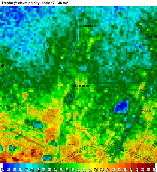
Below is the Elevation map of Trebbo, which displays elevation range with different colors. Scale of the first map is from 17 to 46 m (56 to 151 ft) with average elevation of 28.1 meters (=92 ft) [note 1]
These maps also provides idea of topography and contour of this city, they are displayed at different zoom levels. More info about maps, scale and edge coordinates you can find below images.
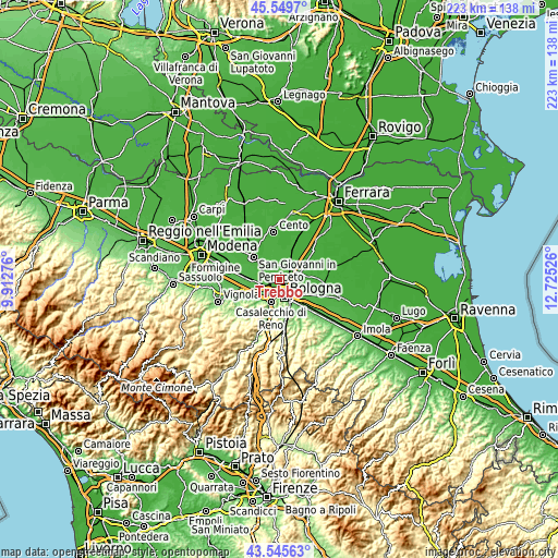
| \ | Map #1 | Topo.Map |
| Scale [m] | 17..46 m | × |
| Scale [ft] | 56..151 ft | × |
| Average | 28.1 m = 92 ft | × |
| Width | 6.96 km = 4.3 mi | 222.8 km = 138.4 mi |
| Height | 6.96 km = 4.3 mi | 222.8 km = 138.4 mi |
| ↑Max Latitude | 44.587595° | 45.5497° |
| Latitude at center | 44.55629° | 44.55629° |
| ↓Min Latitude | 44.524968° | 43.54563° |
| ← Min Longitude | 11.275065° | 9.91276° |
| Longitude center | 11.31901° | 11.31901° |
| →Max Longitude | 11.362955° | 12.72526° |
Nearby cities:
Cities around Trebbo sort by population:
• Bologna elevation 71 m
7.1 km,  167°
167°
• Casalecchio di Reno 71 m
9.6 km,  201°
201°
• Castel Maggiore 29 m
4 km,  55°
55°
• Progresso 24 m
3.8 km,  68°
68°
• Anzola dell'Emilia 41 m
9.1 km,  259°
259°
• Calderara di Reno 28 m
3.9 km,  281°
281°
• Argelato 23 m
9.5 km,  11°
11°
• Padulle 22 m
8.8 km,  337°
337°
• Osteria Nuova 28 m
7.2 km,  295°
295°
• Longara 31 m
2 km,  323°
323°
• Sala Bolognese 21 m
8.1 km, 322°
• Quarto Inferiore 36 m
8.2 km,  110°
110°
Multilingual:
 En español:
Trebbo elevación 32 m.
 En France:
Trebbo élévation 32 m.


Sources and notes:
- [note 1] Map square and city borders are not equal. Map elevation data is calculated only from area inside that square.
- [src 1] Elevation data from geonames database provided with same terms of usage.
- [src 2] The elevation map of Trebbo is generated using elevation data from NASA's 3 arcsec (90m) resolution SRTM data.
- [src 3] Base (background) map © OpenStreetMap contributors tiles are generated by Geofabrik and OpenTopoMap.
Copyright & License:
This Trebbo Elevation Map is licensed under CC BY-SA. You may reuse any part from this page, if you give a proper credit by linking to this URL:
 More info on terms of use page.