Tortoreto Lido elevation
Tortoreto Lido (Abruzzo, Provincia di Teramo), Italy elevation is 2 meters and Tortoreto Lido elevation in feet is 7 ft above sea level [src 1]. Tortoreto Lido is a populated place (feature code) with elevation that is 320 meters (1050 ft) smaller than average city elevation in Italy.
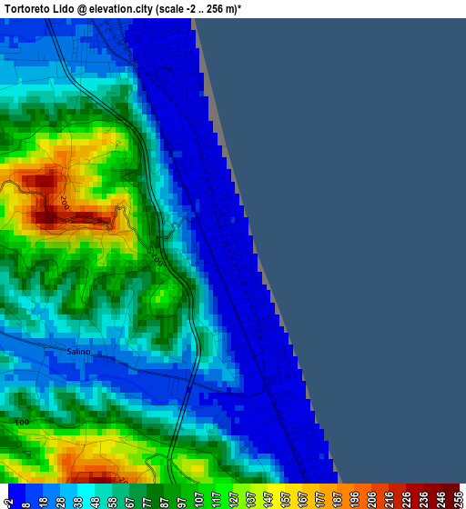
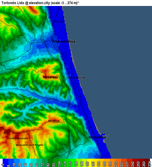
Below is the Elevation map of Tortoreto Lido, which displays elevation range with different colors. Scale of the first map is from -2 to 256 m (-7 to 840 ft) with average elevation of 62.8 meters (=206 ft) [note 1]
These maps also provides idea of topography and contour of this city, they are displayed at different zoom levels. More info about maps, scale and edge coordinates you can find below images.
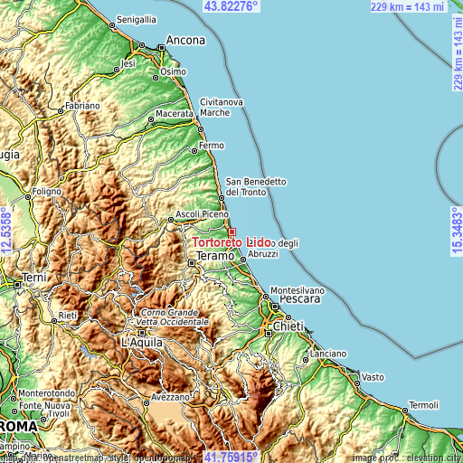
| \ | Map #1 | Map #2 | Topo.Map |
| Scale [m] | -2..256 m | -3..274 m | × |
| Scale [ft] | -7..840 ft | -10..899 ft | × |
| Average | 62.8 m = 206 ft | 87.1 m = 286 ft | × |
| Width | 7.17 km = 4.5 mi | 14.34 km = 8.9 mi | 229.5 km = 142.6 mi |
| Height | 7.17 km = 4.5 mi | 14.34 km = 8.9 mi | 229.4 km = 142.5 mi |
| ↑Max Latitude | 42.831796° | 42.864015° | 43.82276° |
| Latitude at center | 42.79956° | 42.79956° | 42.79956° |
| ↓Min Latitude | 42.767307° | 42.735038° | 41.75915° |
| ← Min Longitude | 13.898105° | 13.854159° | 12.5358° |
| Longitude center | 13.94205° | 13.94205° | 13.94205° |
| →Max Longitude | 13.985995° | 14.029941° | 15.3483° |
Nearby cities:
Cities around Tortoreto Lido sort by population:
• Giulianova elevation 2 m
5.5 km,  158°
158°
• Alba Adriatica 5 m
3.8 km,  339°
339°
• Martinsicuro 0 m
9.3 km,  345°
345°
• Villa Rosa 5 m
5.9 km, 342°
• Mosciano Sant'Angelo 197 m
7.3 km,  216°
216°
• Nereto 138 m
10.1 km,  280°
280°
• Cologna Spiaggia 4 m
9.3 km, 158°
• Corropoli 133 m
9.3 km,  289°
289°
• Colleranesco 39 m
8.7 km,  182°
182°
• Colonnella 249 m
10 km,  323°
323°
• Salino 27 m
2.8 km,  236°
236°
• Tortoreto 218 m
2.4 km, 281°
Multilingual:
 En español:
Tortoreto Lido elevación 2 m.
 En France:
Tortoreto Lido élévation 2 m.
 Auf Deutsch:
Tortoreto Lido höhe über dem Meeresspiegel ist 2 m.

Sources and notes:
- [note 1] Map square and city borders are not equal. Map elevation data is calculated only from area inside that square.
- [src 1] Elevation data from geonames database provided with same terms of usage.
- [src 2] The elevation map of Tortoreto Lido is generated using elevation data from NASA's 3 arcsec (90m) resolution SRTM data.
- [src 3] Base (background) map © OpenStreetMap contributors tiles are generated by Geofabrik and OpenTopoMap.
Copyright & License:
This Tortoreto Lido Elevation Map is licensed under CC BY-SA. You may reuse any part from this page, if you give a proper credit by linking to this URL:
 More info on terms of use page.