Moncrivello elevation
Moncrivello (Piedmont, Provincia di Vercelli), Italy elevation is 304 meters and Moncrivello elevation in feet is 997 ft above sea level [src 1]. Moncrivello is a seat of a third-order administrative division (feature code) with elevation that is 18 meters (59 ft) smaller than average city elevation in Italy.
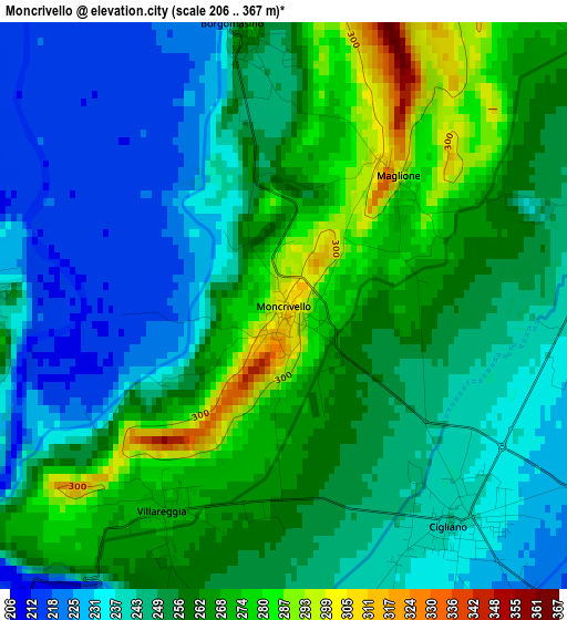
Below is the Elevation map of Moncrivello, which displays elevation range with different colors. Scale of the first map is from 206 to 367 m (676 to 1204 ft) with average elevation of 252.4 meters (=828 ft) [note 1]
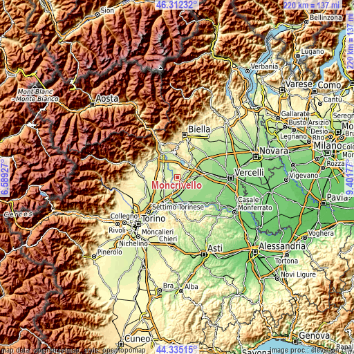
These maps also provides idea of topography and contour of this city, they are displayed at different zoom levels. More info about maps, scale and edge coordinates you can find below images.
| \ | Map #1 | Topo.Map |
| Scale [m] | 206..367 m | × |
| Scale [ft] | 676..1204 ft | × |
| Average | 252.4 m = 828 ft | × |
| Width | 6.87 km = 4.3 mi | 219.8 km = 136.6 mi |
| Height | 6.87 km = 4.3 mi | 219.8 km = 136.6 mi |
| ↑Max Latitude | 45.363245° | 46.31232° |
| Latitude at center | 45.33236° | 45.33236° |
| ↓Min Latitude | 45.301458° | 44.33515° |
| ← Min Longitude | 7.951575° | 6.58927° |
| Longitude center | 7.99552° | 7.99552° |
| →Max Longitude | 8.039465° | 9.40177° |
Nearby cities:
Cities around Moncrivello sort by population:
• Cigliano elevation 238 m
3.5 km,  141°
141°
• Borgo d'Ale 243 m
4.8 km,  66°
66°
• Alice Castello 253 m
7.3 km,  56°
56°
• Tonengo-Casale 252 m
6.7 km,  220°
220°
• Mazze 266 m
6.1 km,  233°
233°
• Vische 231 m
4 km,  275°
275°
• Caravino 264 m
8 km,  339°
339°
• Villareggia 269 m
3 km,  208°
208°
• Borgomasino 258 m
3.4 km,  350°
350°
• Vestignè 237 m
6.9 km,  331°
331°
• Maglione 293 m
2.1 km,  41°
41°
• Cossano Canavese 349 m
6.2 km,  357°
357°
Multilingual:
 En español:
Moncrivello elevación 304 m.
 En France:
Moncrivello élévation 304 m.
 Auf Deutsch:
Moncrivello höhe über dem Meeresspiegel ist 304 m.

Sources and notes:
- [note 1] Map square and city borders are not equal. Map elevation data is calculated only from area inside that square.
- [src 1] Elevation data from geonames database provided with same terms of usage.
- [src 2] The elevation map of Moncrivello is generated using elevation data from NASA's 3 arcsec (90m) resolution SRTM data.
- [src 3] Base (background) map © OpenStreetMap contributors tiles are generated by Geofabrik and OpenTopoMap.
Copyright & License:
This Moncrivello Elevation Map is licensed under CC BY-SA. You may reuse any part from this page, if you give a proper credit by linking to this URL:
 More info on terms of use page.