Vische elevation
Vische (Piedmont, Torino), Italy elevation is 231 meters and Vische elevation in feet is 758 ft above sea level [src 1]. Vische is a seat of a third-order administrative division (feature code) with elevation that is 91 meters (299 ft) smaller than average city elevation in Italy.
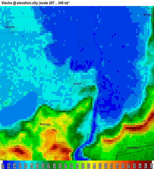
Below is the Elevation map of Vische, which displays elevation range with different colors. Scale of the first map is from 207 to 349 m (679 to 1145 ft) with average elevation of 238.4 meters (=782 ft) [note 1]
These maps also provides idea of topography and contour of this city, they are displayed at different zoom levels. More info about maps, scale and edge coordinates you can find below images.
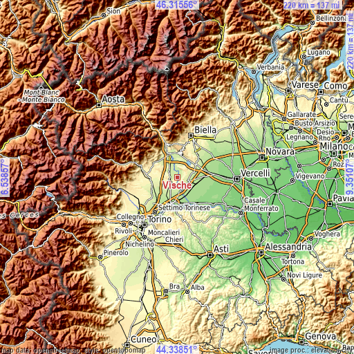
| \ | Map #1 | Topo.Map |
| Scale [m] | 207..349 m | × |
| Scale [ft] | 679..1145 ft | × |
| Average | 238.4 m = 782 ft | × |
| Width | 6.87 km = 4.3 mi | 219.8 km = 136.6 mi |
| Height | 6.87 km = 4.3 mi | 219.8 km = 136.6 mi |
| ↑Max Latitude | 45.366543° | 46.31556° |
| Latitude at center | 45.33566° | 45.33566° |
| ↓Min Latitude | 45.30476° | 44.33851° |
| ← Min Longitude | 7.900875° | 6.53857° |
| Longitude center | 7.94482° | 7.94482° |
| →Max Longitude | 7.988765° | 9.35107° |
Nearby cities:
Cities around Vische sort by population:
• Caluso elevation 288 m
5.4 km,  230°
230°
• Strambino 234 m
6.5 km,  318°
318°
• Tonengo-Casale 252 m
5.5 km,  184°
184°
• Mazze 266 m
4 km,  193°
193°
• Candia Canavese 292 m
4.8 km,  258°
258°
• Moncrivello 304 m
4 km,  95°
95°
• Mercenasco 246 m
5.7 km,  298°
298°
• Villareggia 269 m
3.9 km,  139°
139°
• Borgomasino 258 m
4.5 km,  49°
49°
• Barone Canavese 329 m
5.7 km, 258°
• Vestignè 237 m
5.7 km,  6°
6°
• Maglione 293 m
5.5 km,  77°
77°
Multilingual:
 En español:
Vische elevación 231 m.
 En France:
Vische élévation 231 m.


Sources and notes:
- [note 1] Map square and city borders are not equal. Map elevation data is calculated only from area inside that square.
- [src 1] Elevation data from geonames database provided with same terms of usage.
- [src 2] The elevation map of Vische is generated using elevation data from NASA's 3 arcsec (90m) resolution SRTM data.
- [src 3] Base (background) map © OpenStreetMap contributors tiles are generated by Geofabrik and OpenTopoMap.
Copyright & License:
This Vische Elevation Map is licensed under CC BY-SA. You may reuse any part from this page, if you give a proper credit by linking to this URL:
 More info on terms of use page.