Cigognola elevation
Cigognola (Lombardy, Provincia di Pavia), Italy elevation is 274 meters and Cigognola elevation in feet is 899 ft above sea level [src 1]. Cigognola is a seat of a third-order administrative division (feature code) with elevation that is 48 meters (157 ft) smaller than average city elevation in Italy.
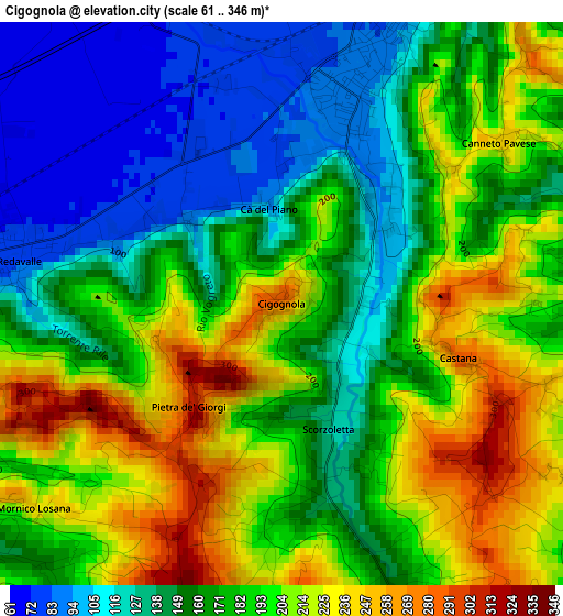
Below is the Elevation map of Cigognola, which displays elevation range with different colors. Scale of the first map is from 61 to 346 m (200 to 1135 ft) with average elevation of 176.9 meters (=580 ft) [note 1]
These maps also provides idea of topography and contour of this city, they are displayed at different zoom levels. More info about maps, scale and edge coordinates you can find below images.
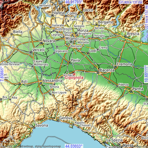
| \ | Map #1 | Topo.Map |
| Scale [m] | 61..346 m | × |
| Scale [ft] | 200..1135 ft | × |
| Average | 176.9 m = 580 ft | × |
| Width | 6.91 km = 4.3 mi | 221 km = 137.3 mi |
| Height | 6.91 km = 4.3 mi | 221 km = 137.3 mi |
| ↑Max Latitude | 45.063808° | 46.01793° |
| Latitude at center | 45.03276° | 45.03276° |
| ↓Min Latitude | 45.001695° | 44.03033° |
| ← Min Longitude | 9.200915° | 7.83861° |
| Longitude center | 9.24486° | 9.24486° |
| →Max Longitude | 9.288805° | 10.65111° |
Nearby cities:
Cities around Cigognola sort by population:
• Broni elevation 82 m
3.7 km,  18°
18°
• Canneto Pavese 246 m
3.3 km,  53°
53°
• Santa Giuletta 80 m
5 km,  271°
271°
• Redavalle 77 m
3.4 km,  279°
279°
• Mornico Losana 238 m
3.9 km,  230°
230°
• Montù Beccaria 213 m
5.3 km,  85°
85°
• Canneto 229 m
3.5 km, 54°
• Mornico 241 m
3.7 km, 228°
• Pietra de' Giorgi 310 m
1.7 km,  221°
221°
• Castana 290 m
2.3 km,  107°
107°
• Lirio 247 m
4.4 km,  167°
167°
• Montescano 198 m
3.1 km, 91°
Multilingual:
 En español:
Cigognola elevación 274 m.
 En France:
Cigognola élévation 274 m.
 Auf Deutsch:
Cigognola höhe über dem Meeresspiegel ist 274 m.

Sources and notes:
- [note 1] Map square and city borders are not equal. Map elevation data is calculated only from area inside that square.
- [src 1] Elevation data from geonames database provided with same terms of usage.
- [src 2] The elevation map of Cigognola is generated using elevation data from NASA's 3 arcsec (90m) resolution SRTM data.
- [src 3] Base (background) map © OpenStreetMap contributors tiles are generated by Geofabrik and OpenTopoMap.
Copyright & License:
This Cigognola Elevation Map is licensed under CC BY-SA. You may reuse any part from this page, if you give a proper credit by linking to this URL:
 More info on terms of use page.