Lirio elevation
Lirio (Lombardy, Provincia di Pavia), Italy elevation is 247 meters and Lirio elevation in feet is 810 ft above sea level [src 1]. Lirio is a seat of a third-order administrative division (feature code) with elevation that is 75 meters (246 ft) smaller than average city elevation in Italy.
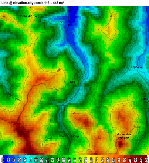
Below is the Elevation map of Lirio, which displays elevation range with different colors. Scale of the first map is from 113 to 448 m (371 to 1470 ft) with average elevation of 262.9 meters (=863 ft) [note 1]
These maps also provides idea of topography and contour of this city, they are displayed at different zoom levels. More info about maps, scale and edge coordinates you can find below images.
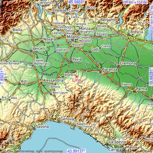
| \ | Map #1 | Topo.Map |
| Scale [m] | 113..448 m | × |
| Scale [ft] | 371..1470 ft | × |
| Average | 262.9 m = 863 ft | × |
| Width | 6.91 km = 4.3 mi | 221.1 km = 137.4 mi |
| Height | 6.91 km = 4.3 mi | 221.1 km = 137.4 mi |
| ↑Max Latitude | 45.025529° | 45.9803° |
| Latitude at center | 44.99446° | 44.99446° |
| ↓Min Latitude | 44.963375° | 43.99137° |
| ← Min Longitude | 9.212615° | 7.85031° |
| Longitude center | 9.25656° | 9.25656° |
| →Max Longitude | 9.300505° | 10.66281° |
Nearby cities:
Cities around Lirio sort by population:
• Santa Maria della Versa elevation 198 m
3.5 km,  102°
102°
• Mornico Losana 238 m
4.3 km,  293°
293°
• Montecalvo Versiggia 357 m
3.4 km,  137°
137°
• Mornico 241 m
4.1 km,  295°
295°
• Montalto Pavese 386 m
3.9 km,  242°
242°
• Pietra de' Giorgi 310 m
3.6 km,  325°
325°
• Cigognola 274 m
4.4 km,  347°
347°
• Castana 290 m
3.8 km,  19°
19°
• Volpara 343 m
5.6 km, 144°
• Golferenzo 432 m
5.4 km,  133°
133°
• Montescano 198 m
4.7 km,  27°
27°
• Villa Fornace 219 m
2.5 km,  187°
187°
Multilingual:
 En español:
Lirio elevación 247 m.
 En France:
Lirio élévation 247 m.


Sources and notes:
- [note 1] Map square and city borders are not equal. Map elevation data is calculated only from area inside that square.
- [src 1] Elevation data from geonames database provided with same terms of usage.
- [src 2] The elevation map of Lirio is generated using elevation data from NASA's 3 arcsec (90m) resolution SRTM data.
- [src 3] Base (background) map © OpenStreetMap contributors tiles are generated by Geofabrik and OpenTopoMap.
Copyright & License:
This Lirio Elevation Map is licensed under CC BY-SA. You may reuse any part from this page, if you give a proper credit by linking to this URL:
 More info on terms of use page.