Cassano Valcuvia elevation
Cassano Valcuvia (Lombardy, Provincia di Varese), Italy elevation is 299 meters and Cassano Valcuvia elevation in feet is 981 ft above sea level [src 1]. Cassano Valcuvia is a seat of a third-order administrative division (feature code) with elevation that is 23 meters (75 ft) smaller than average city elevation in Italy.
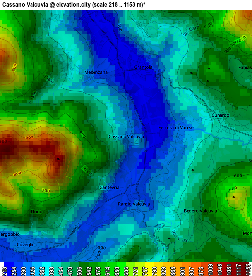
Below is the Elevation map of Cassano Valcuvia, which displays elevation range with different colors. Scale of the first map is from 218 to 1153 m (715 to 3783 ft) with average elevation of 468.6 meters (=1537 ft) [note 1]
These maps also provides idea of topography and contour of this city, they are displayed at different zoom levels. More info about maps, scale and edge coordinates you can find below images.
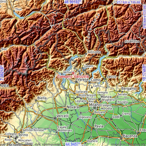
| \ | Map #1 | Topo.Map |
| Scale [m] | 218..1153 m | × |
| Scale [ft] | 715..3783 ft | × |
| Average | 468.6 m = 1537 ft | × |
| Width | 6.8 km = 4.2 mi | 217.5 km = 135.1 mi |
| Height | 6.8 km = 4.2 mi | 217.5 km = 135.1 mi |
| ↑Max Latitude | 45.962936° | 46.90182° |
| Latitude at center | 45.93238° | 45.93238° |
| ↓Min Latitude | 45.901807° | 44.9457° |
| ← Min Longitude | 8.724485° | 7.36218° |
| Longitude center | 8.76843° | 8.76843° |
| →Max Longitude | 8.812375° | 10.17468° |
Nearby cities:
Cities around Cassano Valcuvia sort by population:
• Cuveglio elevation 297 m
4 km,  222°
222°
• Cugliate-Fabiasco 490 m
4.2 km,  69°
69°
• Cunardo 437 m
3 km,  86°
86°
• Mesenzana 243 m
2.2 km,  351°
351°
• Grantola 249 m
1.9 km,  13°
13°
• Bedero Valcuvia 490 m
3.2 km,  138°
138°
• Ferrera di Varese 337 m
1.6 km, 88°
• Rancio Valcuvia 297 m
1.8 km,  172°
172°
• Castello Cabiaglio 520 m
4.4 km,  190°
190°
• Brissago-Valtravaglia 425 m
2.6 km,  317°
317°
• Masciago Primo 340 m
1.9 km,  148°
148°
• Duno 547 m
3.1 km,  229°
229°
Multilingual:
 En español:
Cassano Valcuvia elevación 299 m.
 En France:
Cassano Valcuvia élévation 299 m.
 Auf Deutsch:
Cassano Valcuvia höhe über dem Meeresspiegel ist 299 m.

Sources and notes:
- [note 1] Map square and city borders are not equal. Map elevation data is calculated only from area inside that square.
- [src 1] Elevation data from geonames database provided with same terms of usage.
- [src 2] The elevation map of Cassano Valcuvia is generated using elevation data from NASA's 3 arcsec (90m) resolution SRTM data.
- [src 3] Base (background) map © OpenStreetMap contributors tiles are generated by Geofabrik and OpenTopoMap.
Copyright & License:
This Cassano Valcuvia Elevation Map is licensed under CC BY-SA. You may reuse any part from this page, if you give a proper credit by linking to this URL:
 More info on terms of use page.