Cunardo elevation
Cunardo (Lombardy, Provincia di Varese), Italy elevation is 437 meters and Cunardo elevation in feet is 1434 ft above sea level [src 1]. Cunardo is a seat of a third-order administrative division (feature code) with elevation that is 115 meters (377 ft) bigger than average city elevation in Italy.
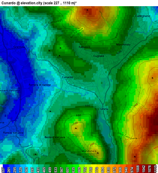
Below is the Elevation map of Cunardo, which displays elevation range with different colors. Scale of the first map is from 227 to 1110 m (745 to 3642 ft) with average elevation of 516.8 meters (=1696 ft) [note 1]
These maps also provides idea of topography and contour of this city, they are displayed at different zoom levels. More info about maps, scale and edge coordinates you can find below images.
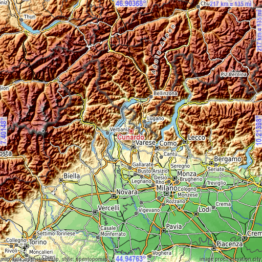
| \ | Map #1 | Topo.Map |
| Scale [m] | 227..1110 m | × |
| Scale [ft] | 745..3642 ft | × |
| Average | 516.8 m = 1696 ft | × |
| Width | 6.8 km = 4.2 mi | 217.5 km = 135.1 mi |
| Height | 6.8 km = 4.2 mi | 217.5 km = 135.1 mi |
| ↑Max Latitude | 45.964835° | 46.90368° |
| Latitude at center | 45.93428° | 45.93428° |
| ↓Min Latitude | 45.903708° | 44.94763° |
| ← Min Longitude | 8.763785° | 7.40148° |
| Longitude center | 8.80773° | 8.80773° |
| →Max Longitude | 8.851675° | 10.21398° |
Nearby cities:
Cities around Cunardo sort by population:
• Marchirolo elevation 476 m
2.5 km,  52°
52°
• Cugliate-Fabiasco 490 m
1.5 km,  33°
33°
• Cadegliano-Viconago 429 m
3.9 km,  44°
44°
• Valganna 461 m
3.8 km,  161°
161°
• Grantola 249 m
3.1 km,  302°
302°
• Bedero Valcuvia 490 m
2.8 km,  199°
199°
• Ganna 468 m
3.8 km, 158°
• Ferrera di Varese 337 m
1.4 km,  263°
263°
• Rancio Valcuvia 297 m
3.5 km,  233°
233°
• Cassano Valcuvia 299 m
3 km,  266°
266°
• Marzio 730 m
3.9 km,  83°
83°
• Masciago Primo 340 m
2.8 km, 228°
Multilingual:
 En español:
Cunardo elevación 437 m.
 En France:
Cunardo élévation 437 m.


Sources and notes:
- [note 1] Map square and city borders are not equal. Map elevation data is calculated only from area inside that square.
- [src 1] Elevation data from geonames database provided with same terms of usage.
- [src 2] The elevation map of Cunardo is generated using elevation data from NASA's 3 arcsec (90m) resolution SRTM data.
- [src 3] Base (background) map © OpenStreetMap contributors tiles are generated by Geofabrik and OpenTopoMap.
Copyright & License:
This Cunardo Elevation Map is licensed under CC BY-SA. You may reuse any part from this page, if you give a proper credit by linking to this URL:
 More info on terms of use page.