Nibbiola elevation
Nibbiola (Piedmont, Provincia di Novara), Italy elevation is 131 meters and Nibbiola elevation in feet is 430 ft above sea level [src 1]. Nibbiola is a seat of a third-order administrative division (feature code) with elevation that is 191 meters (627 ft) smaller than average city elevation in Italy.
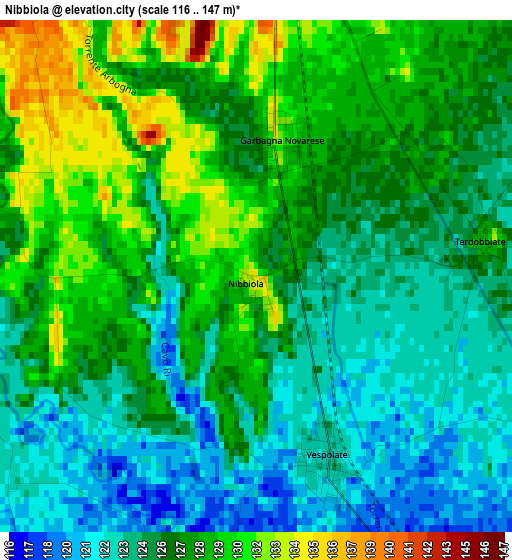
Below is the Elevation map of Nibbiola, which displays elevation range with different colors. Scale of the first map is from 116 to 147 m (381 to 482 ft) with average elevation of 126.1 meters (=414 ft) [note 1]
These maps also provides idea of topography and contour of this city, they are displayed at different zoom levels. More info about maps, scale and edge coordinates you can find below images.
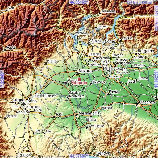
| \ | Map #1 | Topo.Map |
| Scale [m] | 116..147 m | × |
| Scale [ft] | 381..482 ft | × |
| Average | 126.1 m = 414 ft | × |
| Width | 6.87 km = 4.3 mi | 219.7 km = 136.5 mi |
| Height | 6.87 km = 4.3 mi | 219.7 km = 136.5 mi |
| ↑Max Latitude | 45.403223° | 46.35162° |
| Latitude at center | 45.37236° | 45.37236° |
| ↓Min Latitude | 45.34148° | 44.37585° |
| ← Min Longitude | 8.612795° | 7.25049° |
| Longitude center | 8.65674° | 8.65674° |
| →Max Longitude | 8.700685° | 10.06299° |
Nearby cities:
Cities around Nibbiola sort by population:
• Novara elevation 171 m
8.7 km,  341°
341°
• Trecate 137 m
9.3 km,  42°
42°
• Borgolavezzaro 119 m
6.8 km,  150°
150°
• Vespolate 125 m
2.7 km,  159°
159°
• Torrion Quartara 148 m
6.1 km,  327°
327°
• Lumellogno 135 m
6.7 km,  306°
306°
• Confienza 127 m
8.9 km,  239°
239°
• Garbagna Novarese 131 m
1.9 km,  10°
10°
• Granozzo con Monticello 130 m
6.7 km,  258°
258°
• Sozzago 127 m
5.9 km,  60°
60°
• Tornaco 123 m
5.1 km,  110°
110°
• Terdobbiate 128 m
3 km,  82°
82°
Multilingual:
 En español:
Nibbiola elevación 131 m.
 En France:
Nibbiola élévation 131 m.
 Auf Deutsch:
Nibbiola höhe über dem Meeresspiegel ist 131 m.

Sources and notes:
- [note 1] Map square and city borders are not equal. Map elevation data is calculated only from area inside that square.
- [src 1] Elevation data from geonames database provided with same terms of usage.
- [src 2] The elevation map of Nibbiola is generated using elevation data from NASA's 3 arcsec (90m) resolution SRTM data.
- [src 3] Base (background) map © OpenStreetMap contributors tiles are generated by Geofabrik and OpenTopoMap.
Copyright & License:
This Nibbiola Elevation Map is licensed under CC BY-SA. You may reuse any part from this page, if you give a proper credit by linking to this URL:
 More info on terms of use page.