Novara elevation
Novara (Piedmont, Provincia di Novara), Italy elevation is 171 meters and Novara elevation in feet is 561 ft above sea level [src 1]. Novara is a seat of a second-order administrative division (feature code) with elevation that is 151 meters (495 ft) smaller than average city elevation in Italy.
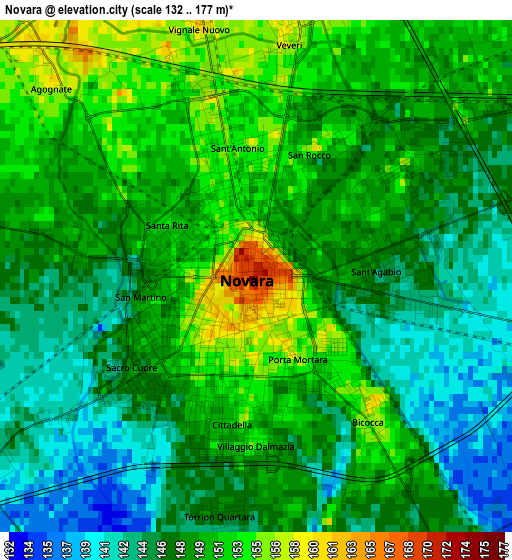
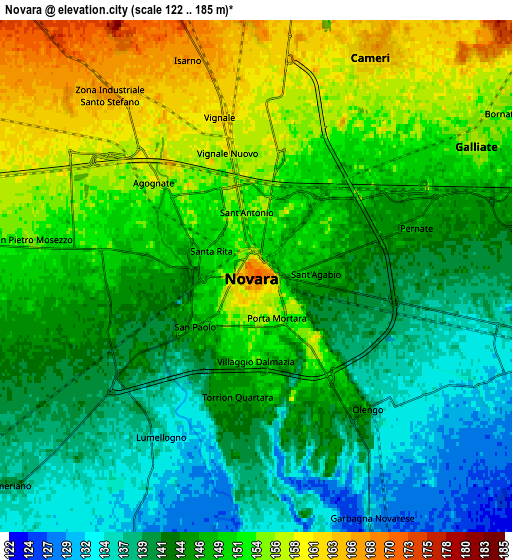
Below is the Elevation map of Novara, which displays elevation range with different colors. Scale of the first map is from 132 to 177 m (433 to 581 ft) with average elevation of 148.3 meters (=487 ft) [note 1]
These maps also provides idea of topography and contour of this city, they are displayed at different zoom levels. More info about maps, scale and edge coordinates you can find below images.
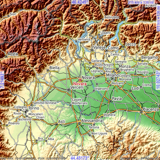
| \ | Map #1 | Map #2 | Topo.Map |
| Scale [m] | 132..177 m | 122..185 m | × |
| Scale [ft] | 433..581 ft | 400..607 ft | × |
| Average | 148.3 m = 487 ft | 147 m = 482 ft | × |
| Width | 6.86 km = 4.3 mi | 13.71 km = 8.5 mi | 219.4 km = 136.3 mi |
| Height | 6.86 km = 4.3 mi | 13.71 km = 8.5 mi | 219.4 km = 136.3 mi |
| ↑Max Latitude | 45.477762° | 45.508568° | 46.4249° |
| Latitude at center | 45.44694° | 45.44694° | 45.44694° |
| ↓Min Latitude | 45.416101° | 45.385245° | 44.45173° |
| ← Min Longitude | 8.577235° | 8.533289° | 7.21493° |
| Longitude center | 8.62118° | 8.62118° | 8.62118° |
| →Max Longitude | 8.665125° | 8.709071° | 10.02743° |
Nearby cities:
Cities around Novara sort by population:
• Trecate elevation 137 m
9.1 km,  99°
99°
• Galliate 156 m
7 km,  58°
58°
• Cameri 169 m
6.9 km,  27°
27°
• Romentino 148 m
7.8 km,  76°
76°
• Pernate 147 m
4.7 km,  72°
72°
• Torrion Quartara 148 m
3.2 km,  188°
188°
• Caltignaga 181 m
8.7 km,  341°
341°
• Lumellogno 135 m
5 km,  210°
210°
• Garbagna Novarese 131 m
7.2 km,  154°
154°
• Sozzago 127 m
9.6 km,  124°
124°
• San Pietro Mosezzo 155 m
6 km,  278°
278°
• Nibbiola 131 m
8.7 km,  161°
161°
Multilingual:
 En español:
Novara elevación 171 m.
 En France:
Novare élévation 171 m.


Sources and notes:
- [note 1] Map square and city borders are not equal. Map elevation data is calculated only from area inside that square.
- [src 1] Elevation data from geonames database provided with same terms of usage.
- [src 2] The elevation map of Novara is generated using elevation data from NASA's 3 arcsec (90m) resolution SRTM data.
- [src 3] Base (background) map © OpenStreetMap contributors tiles are generated by Geofabrik and OpenTopoMap.
Copyright & License:
This Novara Elevation Map is licensed under CC BY-SA. You may reuse any part from this page, if you give a proper credit by linking to this URL:
 More info on terms of use page.