Ragalna elevation
Ragalna (Sicily, Catania), Italy elevation is 778 meters and Ragalna elevation in feet is 2552 ft above sea level [src 1]. Ragalna is a seat of a third-order administrative division (feature code) with elevation that is 456 meters (1496 ft) bigger than average city elevation in Italy.
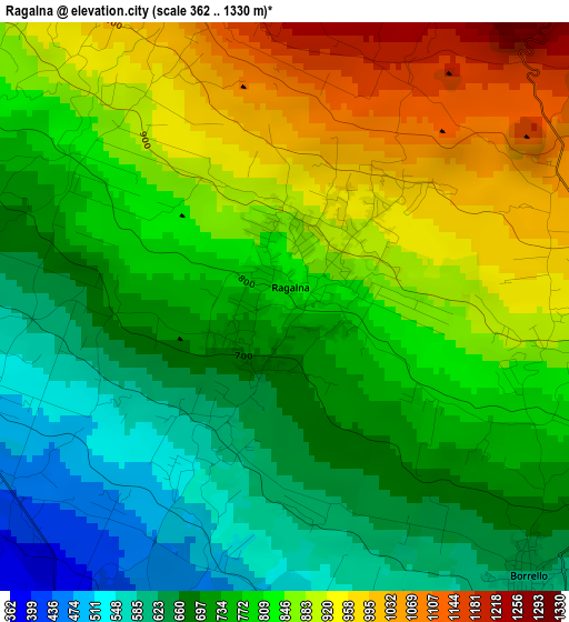
Below is the Elevation map of Ragalna, which displays elevation range with different colors. Scale of the first map is from 362 to 1330 m (1188 to 4364 ft) with average elevation of 788.3 meters (=2586 ft) [note 1]
These maps also provides idea of topography and contour of this city, they are displayed at different zoom levels. More info about maps, scale and edge coordinates you can find below images.
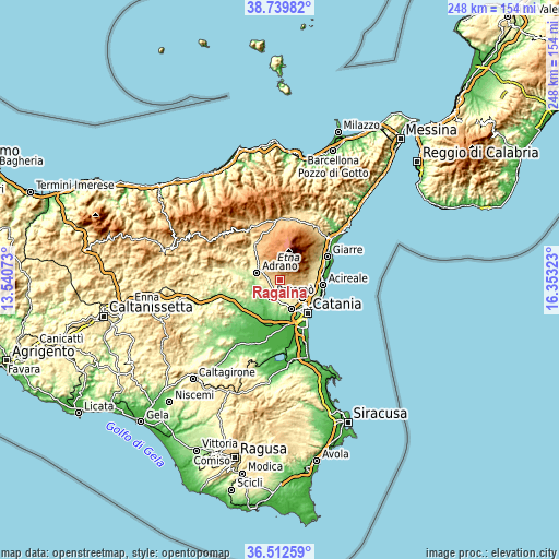
| \ | Map #1 | Topo.Map |
| Scale [m] | 362..1330 m | × |
| Scale [ft] | 1188..4364 ft | × |
| Average | 788.3 m = 2586 ft | × |
| Width | 7.74 km = 4.8 mi | 247.6 km = 153.9 mi |
| Height | 7.74 km = 4.8 mi | 247.6 km = 153.9 mi |
| ↑Max Latitude | 37.669343° | 38.73982° |
| Latitude at center | 37.63455° | 37.63455° |
| ↓Min Latitude | 37.599741° | 36.51259° |
| ← Min Longitude | 14.903035° | 13.54073° |
| Longitude center | 14.94698° | 14.94698° |
| →Max Longitude | 14.990925° | 16.35323° |
Nearby cities:
Cities around Ragalna sort by population:
• Paternò elevation 239 m
8.5 km,  207°
207°
• Adrano 562 m
10.6 km,  287°
287°
• Mascalucia 425 m
11.2 km,  126°
126°
• Biancavilla 519 m
7.1 km,  278°
278°
• Belpasso 559 m
5.6 km,  148°
148°
• Pedara 675 m
9.7 km,  97°
97°
• Nicolosi 758 m
7.3 km, 101°
• San Pietro Clarenza 447 m
9.9 km,  137°
137°
• Santa Maria di Licodia 455 m
5.1 km,  247°
247°
• Camporotondo Etneo 435 m
9.1 km, 147°
• Villaggio del Pino-Le Ginestre 546 m
7.6 km, 138°
• Palazzolo 322 m
8.2 km,  190°
190°
Multilingual:
 En español:
Ragalna elevación 778 m.
 En France:
Ragalna élévation 778 m.


Sources and notes:
- [note 1] Map square and city borders are not equal. Map elevation data is calculated only from area inside that square.
- [src 1] Elevation data from geonames database provided with same terms of usage.
- [src 2] The elevation map of Ragalna is generated using elevation data from NASA's 3 arcsec (90m) resolution SRTM data.
- [src 3] Base (background) map © OpenStreetMap contributors tiles are generated by Geofabrik and OpenTopoMap.
Copyright & License:
This Ragalna Elevation Map is licensed under CC BY-SA. You may reuse any part from this page, if you give a proper credit by linking to this URL:
 More info on terms of use page.