Torrevecchia Pia elevation
Torrevecchia Pia (Lombardy, Provincia di Pavia), Italy elevation is 86 meters and Torrevecchia Pia elevation in feet is 282 ft above sea level [src 1]. Torrevecchia Pia is a seat of a third-order administrative division (feature code) with elevation that is 236 meters (774 ft) smaller than average city elevation in Italy.
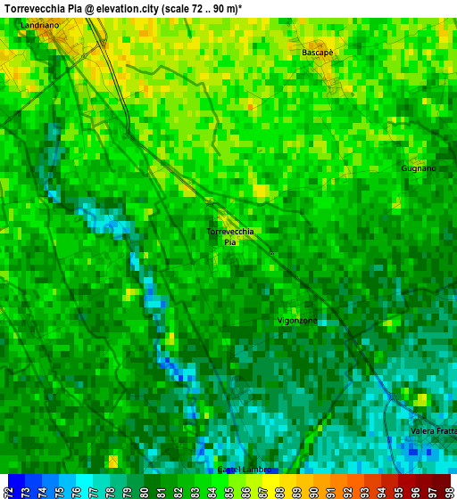
Below is the Elevation map of Torrevecchia Pia, which displays elevation range with different colors. Scale of the first map is from 72 to 90 m (236 to 295 ft) with average elevation of 81.9 meters (=269 ft) [note 1]
These maps also provides idea of topography and contour of this city, they are displayed at different zoom levels. More info about maps, scale and edge coordinates you can find below images.
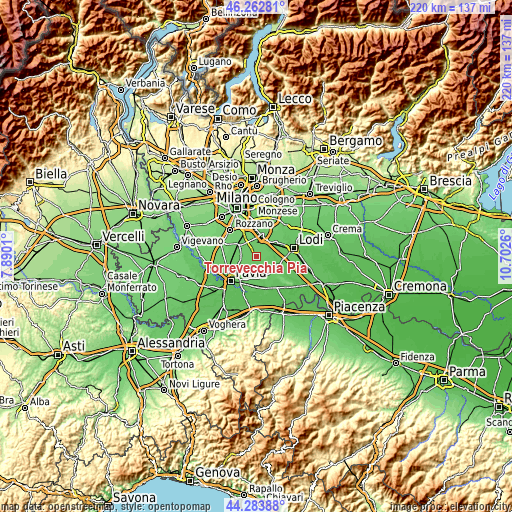
| \ | Map #1 | Topo.Map |
| Scale [m] | 72..90 m | × |
| Scale [ft] | 236..295 ft | × |
| Average | 81.9 m = 269 ft | × |
| Width | 6.88 km = 4.3 mi | 220 km = 136.7 mi |
| Height | 6.88 km = 4.3 mi | 220 km = 136.7 mi |
| ↑Max Latitude | 45.312882° | 46.26281° |
| Latitude at center | 45.28197° | 45.28197° |
| ↓Min Latitude | 45.251041° | 44.28388° |
| ← Min Longitude | 9.252405° | 7.8901° |
| Longitude center | 9.29635° | 9.29635° |
| →Max Longitude | 9.340295° | 10.7026° |
Nearby cities:
Cities around Torrevecchia Pia sort by population:
• Landriano elevation 88 m
4.3 km,  319°
319°
• Vidigulfo 86 m
4.9 km,  283°
283°
• Caselle Lurani 82 m
5 km,  91°
91°
• Mairano 82 m
5.8 km,  57°
57°
• Ceranova 84 m
4.8 km,  239°
239°
• Valera Fratta 77 m
4.2 km,  131°
131°
• Bascapè 87 m
3 km,  27°
27°
• Roncaro 81 m
6.2 km,  195°
195°
• Vigonzone 82 m
1.4 km, 131°
• Torre d'Arese 78 m
4.7 km,  159°
159°
• Marzano 79 m
3.8 km,  181°
181°
• Casaletto Lodigiano 84 m
5.3 km,  76°
76°
Multilingual:
 En español:
Torrevecchia Pia elevación 86 m.
 En France:
Torrevecchia Pia élévation 86 m.
 Auf Deutsch:
Torrevecchia Pia höhe über dem Meeresspiegel ist 86 m.

Sources and notes:
- [note 1] Map square and city borders are not equal. Map elevation data is calculated only from area inside that square.
- [src 1] Elevation data from geonames database provided with same terms of usage.
- [src 2] The elevation map of Torrevecchia Pia is generated using elevation data from NASA's 3 arcsec (90m) resolution SRTM data.
- [src 3] Base (background) map © OpenStreetMap contributors tiles are generated by Geofabrik and OpenTopoMap.
Copyright & License:
This Torrevecchia Pia Elevation Map is licensed under CC BY-SA. You may reuse any part from this page, if you give a proper credit by linking to this URL:
 More info on terms of use page.