Roncaro elevation
Roncaro (Lombardy, Provincia di Pavia), Italy elevation is 81 meters and Roncaro elevation in feet is 266 ft above sea level [src 1]. Roncaro is a seat of a third-order administrative division (feature code) with elevation that is 241 meters (791 ft) smaller than average city elevation in Italy.
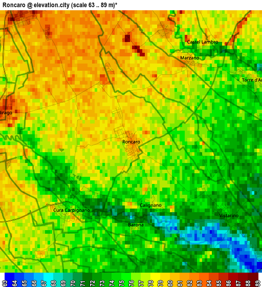
Below is the Elevation map of Roncaro, which displays elevation range with different colors. Scale of the first map is from 63 to 89 m (207 to 292 ft) with average elevation of 76.4 meters (=251 ft) [note 1]
These maps also provides idea of topography and contour of this city, they are displayed at different zoom levels. More info about maps, scale and edge coordinates you can find below images.
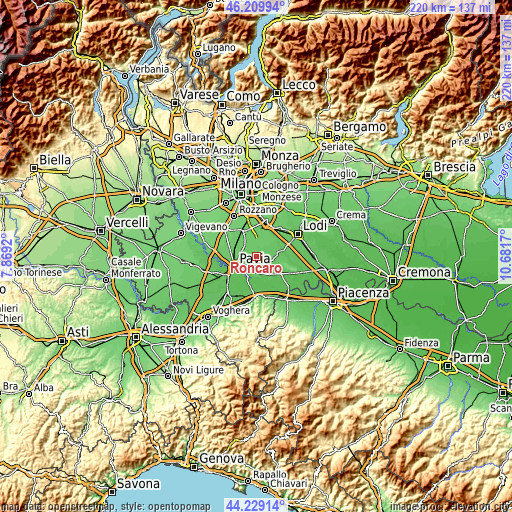
| \ | Map #1 | Topo.Map |
| Scale [m] | 63..89 m | × |
| Scale [ft] | 207..292 ft | × |
| Average | 76.4 m = 251 ft | × |
| Width | 6.88 km = 4.3 mi | 220.2 km = 136.8 mi |
| Height | 6.88 km = 4.3 mi | 220.2 km = 136.8 mi |
| ↑Max Latitude | 45.259112° | 46.20994° |
| Latitude at center | 45.22817° | 45.22817° |
| ↓Min Latitude | 45.197212° | 44.22914° |
| ← Min Longitude | 9.231505° | 7.8692° |
| Longitude center | 9.27545° | 9.27545° |
| →Max Longitude | 9.319395° | 10.6817° |
Nearby cities:
Cities around Roncaro sort by population:
• Cura Carpignano elevation 77 m
2.3 km,  221°
221°
• Albuzzano 75 m
4.6 km,  181°
181°
• Ceranova 84 m
4.4 km,  324°
324°
• Copiano 73 m
5.1 km,  131°
131°
• Magherno 74 m
4.3 km,  96°
96°
• Valera Fratta 77 m
5.7 km,  55°
55°
• Vistarino 73 m
3.2 km, 126°
• Lardirago 85 m
3.4 km,  284°
284°
• Vigonzone 82 m
5.7 km,  28°
28°
• Torre d'Arese 78 m
3.7 km, 63°
• Marzano 79 m
2.7 km, 34°
• Sant'Alessio Con Vialone 82 m
3.9 km,  260°
260°
Multilingual:
 En español:
Roncaro elevación 81 m.
 En France:
Roncaro élévation 81 m.


Sources and notes:
- [note 1] Map square and city borders are not equal. Map elevation data is calculated only from area inside that square.
- [src 1] Elevation data from geonames database provided with same terms of usage.
- [src 2] The elevation map of Roncaro is generated using elevation data from NASA's 3 arcsec (90m) resolution SRTM data.
- [src 3] Base (background) map © OpenStreetMap contributors tiles are generated by Geofabrik and OpenTopoMap.
Copyright & License:
This Roncaro Elevation Map is licensed under CC BY-SA. You may reuse any part from this page, if you give a proper credit by linking to this URL:
 More info on terms of use page.