Mornico al Serio elevation
Mornico al Serio (Lombardy, Provincia di Bergamo), Italy elevation is 164 meters and Mornico al Serio elevation in feet is 538 ft above sea level [src 1]. Mornico al Serio is a seat of a third-order administrative division (feature code) with elevation that is 158 meters (518 ft) smaller than average city elevation in Italy.
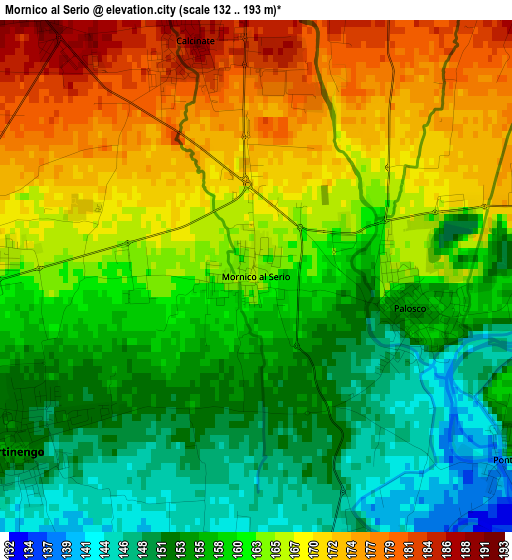
Below is the Elevation map of Mornico al Serio, which displays elevation range with different colors. Scale of the first map is from 132 to 193 m (433 to 633 ft) with average elevation of 161.7 meters (=531 ft) [note 1]
These maps also provides idea of topography and contour of this city, they are displayed at different zoom levels. More info about maps, scale and edge coordinates you can find below images.
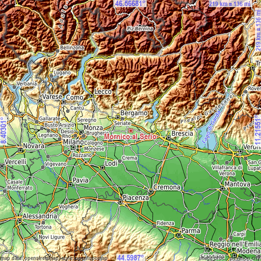
| \ | Map #1 | Topo.Map |
| Scale [m] | 132..193 m | × |
| Scale [ft] | 433..633 ft | × |
| Average | 161.7 m = 531 ft | × |
| Width | 6.84 km = 4.3 mi | 218.8 km = 136 mi |
| Height | 6.84 km = 4.3 mi | 218.8 km = 136 mi |
| ↑Max Latitude | 45.622123° | 46.56681° |
| Latitude at center | 45.59138° | 45.59138° |
| ↓Min Latitude | 45.56062° | 44.5987° |
| ← Min Longitude | 9.765315° | 8.40301° |
| Longitude center | 9.80926° | 9.80926° |
| →Max Longitude | 9.853205° | 11.21551° |
Nearby cities:
Cities around Mornico al Serio sort by population:
• Palazzolo sull'Oglio elevation 178 m
6.1 km,  84°
84°
• Castelli Calepio 190 m
6.4 km,  67°
67°
• Martinengo 152 m
3.9 km,  236°
236°
• Pontoglio 154 m
4.2 km,  125°
125°
• Ghisalba 166 m
4 km,  273°
273°
• Bolgare 196 m
4.6 km,  4°
4°
• Palosco 157 m
2.1 km,  96°
96°
• Calcinate 189 m
3.3 km,  345°
345°
• Cividate al Piano 147 m
4.4 km,  158°
158°
• Telgate 191 m
5.1 km,  37°
37°
• Cavernago 193 m
5.1 km,  317°
317°
• Cortenuova 134 m
6.1 km,  195°
195°
Multilingual:
 En español:
Mornico al Serio elevación 164 m.
 En France:
Mornico al Serio élévation 164 m.
 Auf Deutsch:
Mornico al Serio höhe über dem Meeresspiegel ist 164 m.

Sources and notes:
- [note 1] Map square and city borders are not equal. Map elevation data is calculated only from area inside that square.
- [src 1] Elevation data from geonames database provided with same terms of usage.
- [src 2] The elevation map of Mornico al Serio is generated using elevation data from NASA's 3 arcsec (90m) resolution SRTM data.
- [src 3] Base (background) map © OpenStreetMap contributors tiles are generated by Geofabrik and OpenTopoMap.
Copyright & License:
This Mornico al Serio Elevation Map is licensed under CC BY-SA. You may reuse any part from this page, if you give a proper credit by linking to this URL:
 More info on terms of use page.