Arzago d'Adda elevation
Arzago d'Adda (Lombardy, Provincia di Bergamo), Italy elevation is 105 meters and Arzago d'Adda elevation in feet is 344 ft above sea level [src 1]. Arzago d'Adda is a seat of a third-order administrative division (feature code) with elevation that is 217 meters (712 ft) smaller than average city elevation in Italy.
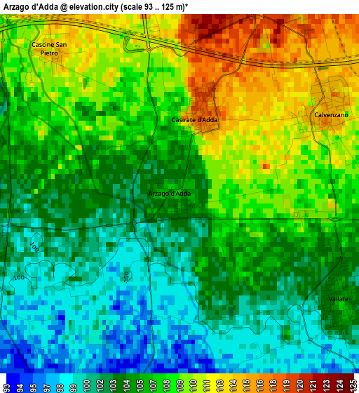
Below is the Elevation map of Arzago d'Adda, which displays elevation range with different colors. Scale of the first map is from 93 to 125 m (305 to 410 ft) with average elevation of 105.8 meters (=347 ft) [note 1]
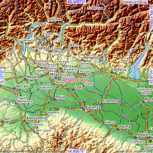
These maps also provides idea of topography and contour of this city, they are displayed at different zoom levels. More info about maps, scale and edge coordinates you can find below images.
| \ | Map #1 | Topo.Map |
| Scale [m] | 93..125 m | × |
| Scale [ft] | 305..410 ft | × |
| Average | 105.8 m = 347 ft | × |
| Width | 6.85 km = 4.3 mi | 219.3 km = 136.3 mi |
| Height | 6.85 km = 4.3 mi | 219.3 km = 136.3 mi |
| ↑Max Latitude | 45.512173° | 46.45872° |
| Latitude at center | 45.48137° | 45.48137° |
| ↓Min Latitude | 45.45055° | 44.48676° |
| ← Min Longitude | 9.520205° | 8.1579° |
| Longitude center | 9.56415° | 9.56415° |
| →Max Longitude | 9.608095° | 10.9704° |
Nearby cities:
Cities around Arzago d'Adda sort by population:
• Treviglio elevation 128 m
4.9 km,  25°
25°
• Cassano d'Adda 135 m
6.3 km,  322°
322°
• Caravaggio 114 m
6.3 km,  74°
74°
• Rivolta d'Adda 105 m
4.2 km,  252°
252°
• Vailate 107 m
3.7 km,  124°
124°
• Calvenzano 116 m
3.2 km,  59°
59°
• Agnadello 97 m
4.1 km,  191°
191°
• Casirate d'Adda 118 m
1.6 km,  14°
14°
• Misano di Gera d'Adda 109 m
4.6 km,  106°
106°
• Albignano 117 m
5.9 km,  291°
291°
• Geromina 131 m
6.2 km, 8°
• Badalasco 126 m
6.8 km,  353°
353°
Multilingual:
 En español:
Arzago d'Adda elevación 105 m.
 En France:
Arzago d'Adda élévation 105 m.
 Auf Deutsch:
Arzago d'Adda höhe über dem Meeresspiegel ist 105 m.

Sources and notes:
- [note 1] Map square and city borders are not equal. Map elevation data is calculated only from area inside that square.
- [src 1] Elevation data from geonames database provided with same terms of usage.
- [src 2] The elevation map of Arzago d'Adda is generated using elevation data from NASA's 3 arcsec (90m) resolution SRTM data.
- [src 3] Base (background) map © OpenStreetMap contributors tiles are generated by Geofabrik and OpenTopoMap.
Copyright & License:
This Arzago d'Adda Elevation Map is licensed under CC BY-SA. You may reuse any part from this page, if you give a proper credit by linking to this URL:
 More info on terms of use page.