Spriana elevation
Spriana (Lombardy, Provincia di Sondrio), Italy elevation is 745 meters and Spriana elevation in feet is 2444 ft above sea level [src 1]. Spriana is a seat of a third-order administrative division (feature code) with elevation that is 423 meters (1388 ft) bigger than average city elevation in Italy.
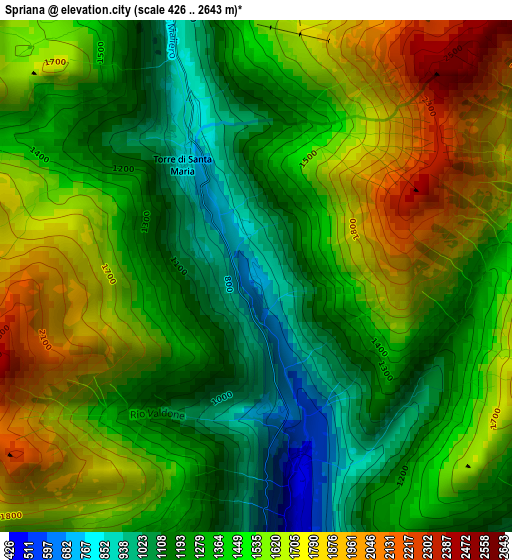
Below is the Elevation map of Spriana, which displays elevation range with different colors. Scale of the first map is from 426 to 2643 m (1398 to 8671 ft) with average elevation of 1448.9 meters (=4754 ft) [note 1]
These maps also provides idea of topography and contour of this city, they are displayed at different zoom levels. More info about maps, scale and edge coordinates you can find below images.
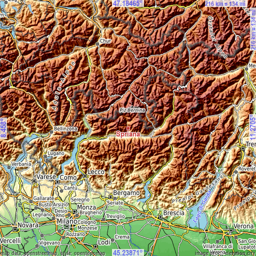
| \ | Map #1 | Topo.Map |
| Scale [m] | 426..2643 m | × |
| Scale [ft] | 1398..8671 ft | × |
| Average | 1448.9 m = 4754 ft | × |
| Width | 6.76 km = 4.2 mi | 216.4 km = 134.5 mi |
| Height | 6.76 km = 4.2 mi | 216.4 km = 134.5 mi |
| ↑Max Latitude | 46.250697° | 47.18465° |
| Latitude at center | 46.2203° | 46.2203° |
| ↓Min Latitude | 46.189886° | 45.23871° |
| ← Min Longitude | 9.820305° | 8.458° |
| Longitude center | 9.86425° | 9.86425° |
| →Max Longitude | 9.908195° | 11.2705° |
Nearby cities:
Cities around Spriana sort by population:
• Sondrio elevation 304 m
5.8 km,  174°
174°
• Torchione-Moia 334 m
7.3 km,  182°
182°
• Chiesa in Valmalenco 1009 m
5.3 km,  347°
347°
• Montagna in Valtellina 554 m
5.5 km,  147°
147°
• Tresivio 500 m
7.8 km,  129°
129°
• Castione Andevenno 447 m
7.2 km,  222°
222°
• Caspoggio 1075 m
4.9 km,  357°
357°
• Lanzada 979 m
5.5 km,  4°
4°
• Poggiridenti Piano 299 m
7.4 km,  139°
139°
• Castione 447 m
7.2 km, 223°
• Poggiridenti Alto 494 m
6.9 km, 136°
• Torre di Santa Maria 779 m
1.7 km,  328°
328°
Multilingual:
 En español:
Spriana elevación 745 m.
 En France:
Spriana élévation 745 m.


Sources and notes:
- [note 1] Map square and city borders are not equal. Map elevation data is calculated only from area inside that square.
- [src 1] Elevation data from geonames database provided with same terms of usage.
- [src 2] The elevation map of Spriana is generated using elevation data from NASA's 3 arcsec (90m) resolution SRTM data.
- [src 3] Base (background) map © OpenStreetMap contributors tiles are generated by Geofabrik and OpenTopoMap.
Copyright & License:
This Spriana Elevation Map is licensed under CC BY-SA. You may reuse any part from this page, if you give a proper credit by linking to this URL:
 More info on terms of use page.