Solignano elevation
Solignano (Emilia-Romagna, Provincia di Parma), Italy elevation is 256 meters and Solignano elevation in feet is 840 ft above sea level [src 1]. Solignano is a seat of a third-order administrative division (feature code) with elevation that is 66 meters (217 ft) smaller than average city elevation in Italy.
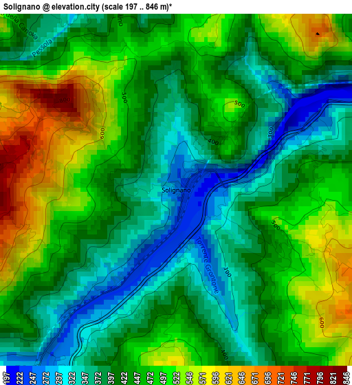
Below is the Elevation map of Solignano, which displays elevation range with different colors. Scale of the first map is from 197 to 846 m (646 to 2776 ft) with average elevation of 438.1 meters (=1437 ft) [note 1]
These maps also provides idea of topography and contour of this city, they are displayed at different zoom levels. More info about maps, scale and edge coordinates you can find below images.
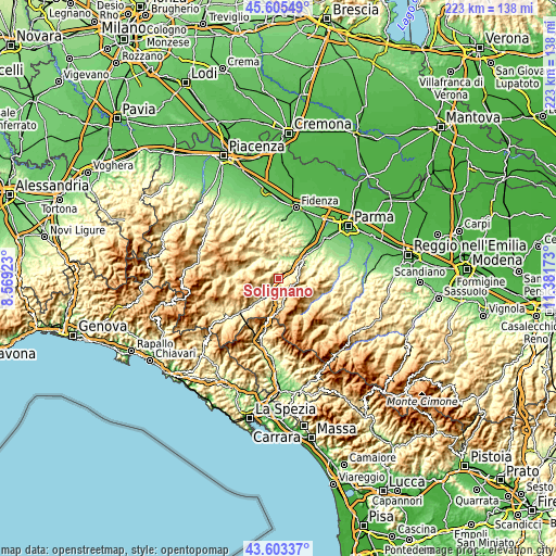
| \ | Map #1 | Topo.Map |
| Scale [m] | 197..846 m | × |
| Scale [ft] | 646..2776 ft | × |
| Average | 438.1 m = 1437 ft | × |
| Width | 6.96 km = 4.3 mi | 222.6 km = 138.3 mi |
| Height | 6.96 km = 4.3 mi | 222.6 km = 138.3 mi |
| ↑Max Latitude | 44.644335° | 45.60549° |
| Latitude at center | 44.61306° | 44.61306° |
| ↓Min Latitude | 44.581768° | 43.60337° |
| ← Min Longitude | 9.931535° | 8.56923° |
| Longitude center | 9.97548° | 9.97548° |
| →Max Longitude | 10.019425° | 11.38173° |
Nearby cities:
Cities around Solignano sort by population:
• Fornovo di Taro elevation 136 m
13.5 km,  47°
47°
• Felegara 128 m
16.3 km,  41°
41°
• Ramiola 156 m
13.4 km, 43°
• Varano De' Melegari 205 m
8.8 km,  18°
18°
• Riccò 139 m
15.1 km, 49°
• Ozzano Taro 136 m
16.9 km, 50°
• Berceto 809 m
11.6 km,  173°
173°
• Calestano 397 m
11.8 km,  95°
95°
• Varsi 449 m
11.4 km,  298°
298°
• Pellegrino Parmense 427 m
13.4 km,  345°
345°
• Terenzo 548 m
9 km,  91°
91°
• Stazione Valmozzola 273 m
4.6 km,  214°
214°
Multilingual:
 En español:
Solignano elevación 256 m.
 En France:
Solignano élévation 256 m.
 Auf Deutsch:
Solignano höhe über dem Meeresspiegel ist 256 m.

Sources and notes:
- [note 1] Map square and city borders are not equal. Map elevation data is calculated only from area inside that square.
- [src 1] Elevation data from geonames database provided with same terms of usage.
- [src 2] The elevation map of Solignano is generated using elevation data from NASA's 3 arcsec (90m) resolution SRTM data.
- [src 3] Base (background) map © OpenStreetMap contributors tiles are generated by Geofabrik and OpenTopoMap.
Copyright & License:
This Solignano Elevation Map is licensed under CC BY-SA. You may reuse any part from this page, if you give a proper credit by linking to this URL:
 More info on terms of use page.