Calestano elevation
Calestano (Emilia-Romagna, Provincia di Parma), Italy elevation is 397 meters and Calestano elevation in feet is 1302 ft above sea level [src 1]. Calestano is a seat of a third-order administrative division (feature code) with elevation that is 75 meters (246 ft) bigger than average city elevation in Italy.
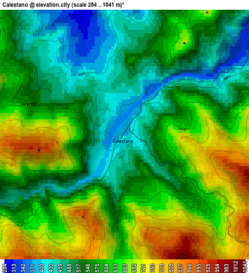
Below is the Elevation map of Calestano, which displays elevation range with different colors. Scale of the first map is from 284 to 1041 m (932 to 3415 ft) with average elevation of 586.1 meters (=1923 ft) [note 1]
These maps also provides idea of topography and contour of this city, they are displayed at different zoom levels. More info about maps, scale and edge coordinates you can find below images.
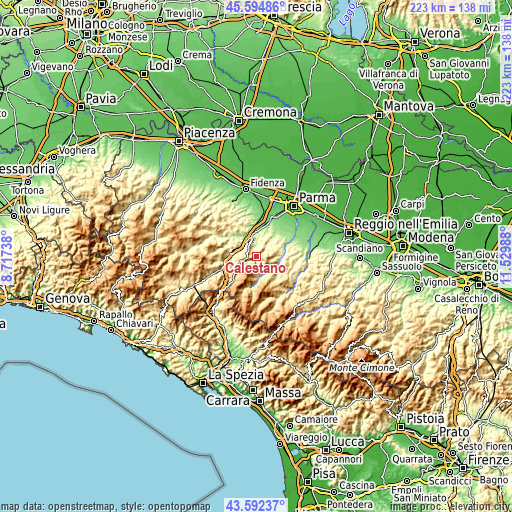
| \ | Map #1 | Topo.Map |
| Scale [m] | 284..1041 m | × |
| Scale [ft] | 932..3415 ft | × |
| Average | 586.1 m = 1923 ft | × |
| Width | 6.96 km = 4.3 mi | 222.7 km = 138.4 mi |
| Height | 6.96 km = 4.3 mi | 222.6 km = 138.3 mi |
| ↑Max Latitude | 44.633521° | 45.59486° |
| Latitude at center | 44.60224° | 44.60224° |
| ↓Min Latitude | 44.570943° | 43.59237° |
| ← Min Longitude | 10.079685° | 8.71738° |
| Longitude center | 10.12363° | 10.12363° |
| →Max Longitude | 10.167575° | 11.52988° |
Nearby cities:
Cities around Calestano sort by population:
• Langhirano elevation 274 m
11.5 km,  80°
80°
• Felino 181 m
14.1 km,  40°
40°
• Fornovo di Taro 136 m
10.4 km,  350°
350°
• Felegara 128 m
13.3 km,  356°
356°
• Ramiola 156 m
11.2 km, 346°
• Varano De' Melegari 205 m
13 km,  317°
317°
• Riccò 139 m
10.9 km, 358°
• Ozzano Taro 136 m
12 km,  6°
6°
• Gaiano 118 m
14.1 km,  15°
15°
• Solignano 256 m
11.8 km,  275°
275°
• Tizzano Val Parma 796 m
11 km,  147°
147°
• Terenzo 548 m
2.8 km,  288°
288°
Multilingual:
 En español:
Calestano elevación 397 m.
 En France:
Calestano élévation 397 m.
 Auf Deutsch:
Calestano höhe über dem Meeresspiegel ist 397 m.

Sources and notes:
- [note 1] Map square and city borders are not equal. Map elevation data is calculated only from area inside that square.
- [src 1] Elevation data from geonames database provided with same terms of usage.
- [src 2] The elevation map of Calestano is generated using elevation data from NASA's 3 arcsec (90m) resolution SRTM data.
- [src 3] Base (background) map © OpenStreetMap contributors tiles are generated by Geofabrik and OpenTopoMap.
Copyright & License:
This Calestano Elevation Map is licensed under CC BY-SA. You may reuse any part from this page, if you give a proper credit by linking to this URL:
 More info on terms of use page.