Roghudi elevation
Roghudi (Calabria, Provincia di Reggio Calabria), Italy elevation is 43 meters and Roghudi elevation in feet is 141 ft above sea level [src 1]. Roghudi is a seat of a third-order administrative division (feature code) with elevation that is 279 meters (915 ft) smaller than average city elevation in Italy.
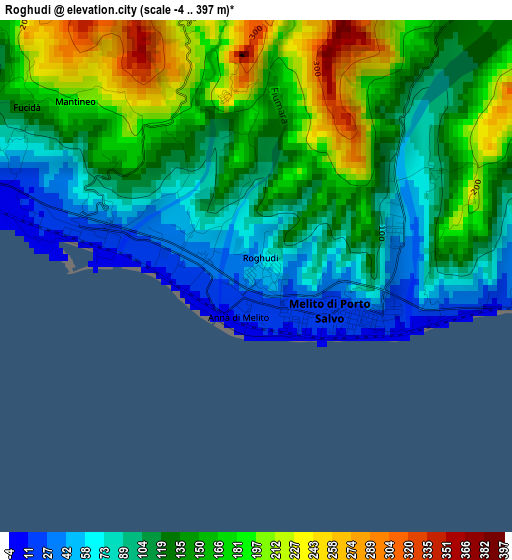
Below is the Elevation map of Roghudi, which displays elevation range with different colors. Scale of the first map is from -4 to 397 m (-13 to 1302 ft) with average elevation of 131.7 meters (=432 ft) [note 1]
These maps also provides idea of topography and contour of this city, they are displayed at different zoom levels. More info about maps, scale and edge coordinates you can find below images.
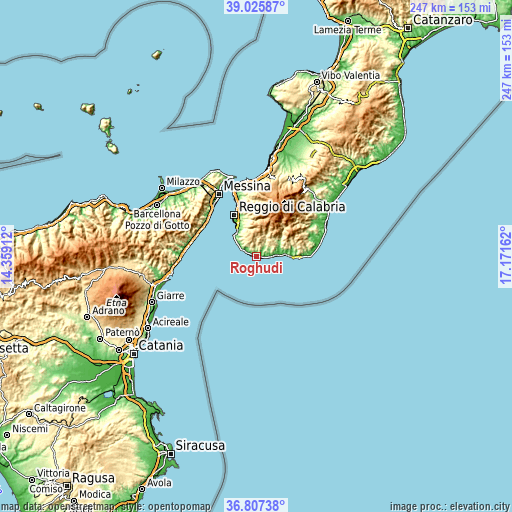
| \ | Map #1 | Topo.Map |
| Scale [m] | -4..397 m | × |
| Scale [ft] | -13..1302 ft | × |
| Average | 131.7 m = 432 ft | × |
| Width | 7.71 km = 4.8 mi | 246.7 km = 153.3 mi |
| Height | 7.71 km = 4.8 mi | 246.7 km = 153.3 mi |
| ↑Max Latitude | 37.959647° | 39.02587° |
| Latitude at center | 37.92499° | 37.92499° |
| ↓Min Latitude | 37.890317° | 36.80738° |
| ← Min Longitude | 15.721425° | 14.35912° |
| Longitude center | 15.76537° | 15.76537° |
| →Max Longitude | 15.809315° | 17.17162° |
Nearby cities:
Cities around Roghudi sort by population:
• Pellaro elevation 37 m
14.4 km,  315°
315°
• Melito di Porto Salvo 16 m
1.4 km,  276°
276°
• San Carlo-Condofuri Marina 22 m
9.4 km,  84°
84°
• Bova Marina 29 m
13.4 km,  85°
85°
• Lazzaro 16 m
10.3 km,  301°
301°
• Saline Ioniche 13 m
4.3 km,  291°
291°
• Motta San Giovanni 610 m
10.5 km,  334°
334°
• Fossato Ionico-Fossatello-San Luca Marcelluzzo 565 m
9.5 km,  358°
358°
• Bagaladi 479 m
12.2 km,  23°
23°
• San Lorenzo 789 m
11.3 km,  32°
32°
• Montebello Jonico 399 m
6.5 km,  354°
354°
• Condofuri 335 m
12 km,  42°
42°
Multilingual:
 En español:
Roghudi elevación 43 m.
 En France:
Roghudi élévation 43 m.


Sources and notes:
- [note 1] Map square and city borders are not equal. Map elevation data is calculated only from area inside that square.
- [src 1] Elevation data from geonames database provided with same terms of usage.
- [src 2] The elevation map of Roghudi is generated using elevation data from NASA's 3 arcsec (90m) resolution SRTM data.
- [src 3] Base (background) map © OpenStreetMap contributors tiles are generated by Geofabrik and OpenTopoMap.
Copyright & License:
This Roghudi Elevation Map is licensed under CC BY-SA. You may reuse any part from this page, if you give a proper credit by linking to this URL:
 More info on terms of use page.