Paderno del Grappa elevation
Paderno del Grappa (Veneto, Provincia di Treviso), Italy elevation is 290 meters and Paderno del Grappa elevation in feet is 951 ft above sea level [src 1]. Paderno del Grappa is a seat of a third-order administrative division (feature code) with elevation that is 32 meters (105 ft) smaller than average city elevation in Italy.
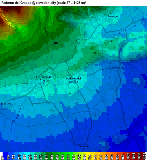
Below is the Elevation map of Paderno del Grappa, which displays elevation range with different colors. Scale of the first map is from 97 to 1128 m (318 to 3701 ft) with average elevation of 281.3 meters (=923 ft) [note 1]
These maps also provides idea of topography and contour of this city, they are displayed at different zoom levels. More info about maps, scale and edge coordinates you can find below images.
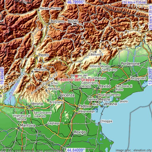
| \ | Map #1 | Topo.Map |
| Scale [m] | 97..1128 m | × |
| Scale [ft] | 318..3701 ft | × |
| Average | 281.3 m = 923 ft | × |
| Width | 6.81 km = 4.2 mi | 217.9 km = 135.4 mi |
| Height | 6.81 km = 4.2 mi | 217.9 km = 135.4 mi |
| ↑Max Latitude | 45.859213° | 46.79986° |
| Latitude at center | 45.8286° | 45.8286° |
| ↓Min Latitude | 45.79797° | 44.84009° |
| ← Min Longitude | 11.813755° | 10.45145° |
| Longitude center | 11.8577° | 11.8577° |
| →Max Longitude | 11.901645° | 13.26395° |
Nearby cities:
Cities around Paderno del Grappa sort by population:
• San Zenone degli Ezzelini elevation 116 m
5.6 km,  196°
196°
• Borso del Grappa 185 m
6.8 km,  252°
252°
• Crespano del Grappa 303 m
1.9 km,  267°
267°
• Onè 103 m
5.1 km,  165°
165°
• Asolo 101 m
6.4 km,  134°
134°
• Mussolente 113 m
6.8 km,  216°
216°
• Cavaso del Tomba 245 m
4.8 km,  41°
41°
• Possagno 235 m
3 km, 44°
• Caniezza 213 m
4.2 km,  50°
50°
• Castelcucco 189 m
2 km,  84°
84°
• Paderno 289 m
0.1 km,  239°
239°
• Monfumo 195 m
4.9 km,  87°
87°
Multilingual:
 En español:
Paderno del Grappa elevación 290 m.
 En France:
Paderno del Grappa élévation 290 m.
 Auf Deutsch:
Paderno del Grappa höhe über dem Meeresspiegel ist 290 m.
 На русском:
Paderno del Grappa высота над уровнем моря 290 м
Sources and notes:
- [note 1] Map square and city borders are not equal. Map elevation data is calculated only from area inside that square.
- [src 1] Elevation data from geonames database provided with same terms of usage.
- [src 2] The elevation map of Paderno del Grappa is generated using elevation data from NASA's 3 arcsec (90m) resolution SRTM data.
- [src 3] Base (background) map © OpenStreetMap contributors tiles are generated by Geofabrik and OpenTopoMap.
Copyright & License:
This Paderno del Grappa Elevation Map is licensed under CC BY-SA. You may reuse any part from this page, if you give a proper credit by linking to this URL:
 More info on terms of use page.