Sardigliano elevation
Sardigliano (Piedmont, Provincia di Alessandria), Italy elevation is 239 meters and Sardigliano elevation in feet is 784 ft above sea level [src 1]. Sardigliano is a seat of a third-order administrative division (feature code) with elevation that is 83 meters (272 ft) smaller than average city elevation in Italy.
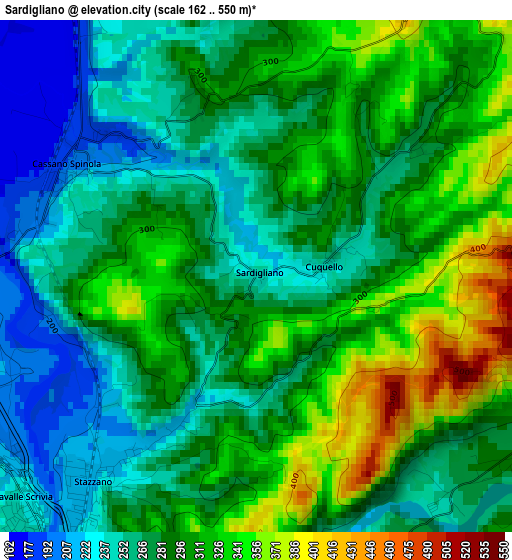
Below is the Elevation map of Sardigliano, which displays elevation range with different colors. Scale of the first map is from 162 to 550 m (531 to 1804 ft) with average elevation of 288.9 meters (=948 ft) [note 1]
These maps also provides idea of topography and contour of this city, they are displayed at different zoom levels. More info about maps, scale and edge coordinates you can find below images.
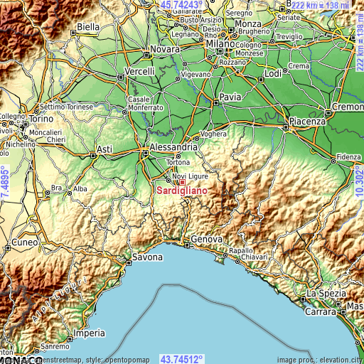
| \ | Map #1 | Topo.Map |
| Scale [m] | 162..550 m | × |
| Scale [ft] | 531..1804 ft | × |
| Average | 288.9 m = 948 ft | × |
| Width | 6.94 km = 4.3 mi | 222.1 km = 138 mi |
| Height | 6.94 km = 4.3 mi | 222.1 km = 138 mi |
| ↑Max Latitude | 44.7836° | 45.74243° |
| Latitude at center | 44.7524° | 44.7524° |
| ↓Min Latitude | 44.721184° | 43.74512° |
| ← Min Longitude | 8.851805° | 7.4895° |
| Longitude center | 8.89575° | 8.89575° |
| →Max Longitude | 8.939695° | 10.302° |
Nearby cities:
Cities around Sardigliano sort by population:
• Serravalle Scrivia elevation 233 m
4.5 km,  223°
223°
• Arquata Scrivia 246 m
7.2 km,  185°
185°
• Stazzano 221 m
3.5 km, 217°
• Vignole Borbera 245 m
4.9 km, 185°
• Cassano Spinola 190 m
3 km,  298°
298°
• Villalvernia 165 m
7.5 km,  334°
334°
• Borghetto di Borbera 289 m
4.6 km,  124°
124°
• Sant'Agata Fossili 437 m
4.1 km,  29°
29°
• Carezzano Maggiore 293 m
6.1 km,  3°
3°
• Costa Vescovato 288 m
7.5 km,  19°
19°
• Gavazzana 318 m
2.7 km,  343°
343°
• Castellania 384 m
5.8 km, 28°
Multilingual:
 En español:
Sardigliano elevación 239 m.
 En France:
Sardigliano élévation 239 m.
 Auf Deutsch:
Sardigliano höhe über dem Meeresspiegel ist 239 m.

Sources and notes:
- [note 1] Map square and city borders are not equal. Map elevation data is calculated only from area inside that square.
- [src 1] Elevation data from geonames database provided with same terms of usage.
- [src 2] The elevation map of Sardigliano is generated using elevation data from NASA's 3 arcsec (90m) resolution SRTM data.
- [src 3] Base (background) map © OpenStreetMap contributors tiles are generated by Geofabrik and OpenTopoMap.
Copyright & License:
This Sardigliano Elevation Map is licensed under CC BY-SA. You may reuse any part from this page, if you give a proper credit by linking to this URL:
 More info on terms of use page.