Villalvernia elevation
Villalvernia (Piedmont, Provincia di Alessandria), Italy elevation is 165 meters and Villalvernia elevation in feet is 541 ft above sea level [src 1]. Villalvernia is a seat of a third-order administrative division (feature code) with elevation that is 157 meters (515 ft) smaller than average city elevation in Italy.
Below is the Elevation map of Villalvernia, which displays elevation range with different colors. Scale of the first map is from 131 to 329 m (430 to 1079 ft) with average elevation of 184.5 meters (=605 ft) [note 1]
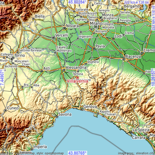
These maps also provides idea of topography and contour of this city, they are displayed at different zoom levels. More info about maps, scale and edge coordinates you can find below images.
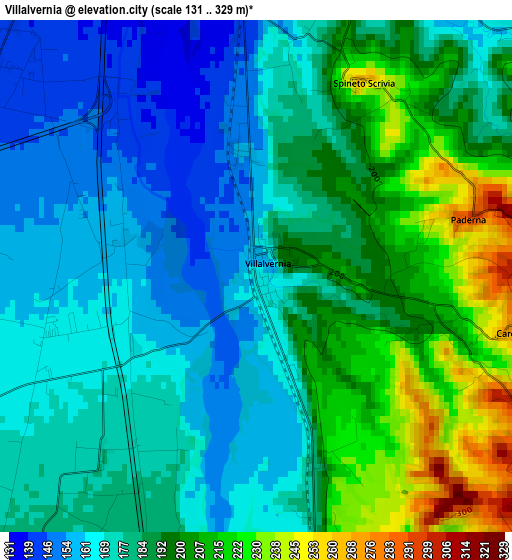
| \ | Map #1 | Topo.Map |
| Scale [m] | 131..329 m | × |
| Scale [ft] | 430..1079 ft | × |
| Average | 184.5 m = 605 ft | × |
| Width | 6.93 km = 4.3 mi | 221.8 km = 137.8 mi |
| Height | 6.93 km = 4.3 mi | 221.8 km = 137.8 mi |
| ↑Max Latitude | 44.845036° | 45.80284° |
| Latitude at center | 44.81387° | 44.81387° |
| ↓Min Latitude | 44.782687° | 43.80765° |
| ← Min Longitude | 8.811375° | 7.44907° |
| Longitude center | 8.85532° | 8.85532° |
| →Max Longitude | 8.899265° | 10.26157° |
Nearby cities:
Cities around Villalvernia sort by population:
• Pozzolo Formigaro elevation 162 m
5.9 km,  253°
253°
• Cassano Spinola 190 m
5.4 km,  174°
174°
• Villaromagnano 169 m
4.7 km,  32°
32°
• Carbonara Scrivia 179 m
4.1 km,  16°
16°
• Spineto Scrivia 262 m
3 km, 29°
• Sant'Agata Fossili 437 m
6.1 km,  121°
121°
• Paderna 267 m
2.9 km,  73°
73°
• Cerreto Grue 242 m
6.7 km,  61°
61°
• Carezzano Maggiore 293 m
3.6 km,  101°
101°
• Costa Vescovato 288 m
5.7 km,  87°
87°
• Gavazzana 318 m
4.9 km,  150°
150°
• Castellania 384 m
6.2 km,  106°
106°
Multilingual:
 En español:
Villalvernia elevación 165 m.
 En France:
Villalvernia élévation 165 m.
 Auf Deutsch:
Villalvernia höhe über dem Meeresspiegel ist 165 m.

Sources and notes:
- [note 1] Map square and city borders are not equal. Map elevation data is calculated only from area inside that square.
- [src 1] Elevation data from geonames database provided with same terms of usage.
- [src 2] The elevation map of Villalvernia is generated using elevation data from NASA's 3 arcsec (90m) resolution SRTM data.
- [src 3] Base (background) map © OpenStreetMap contributors tiles are generated by Geofabrik and OpenTopoMap.
Copyright & License:
This Villalvernia Elevation Map is licensed under CC BY-SA. You may reuse any part from this page, if you give a proper credit by linking to this URL:
 More info on terms of use page.