Sover elevation
Sover (Trentino-Alto Adige, Provincia autonoma di Trento), Italy elevation is 842 meters and Sover elevation in feet is 2762 ft above sea level [src 1]. Sover is a seat of a third-order administrative division (feature code) with elevation that is 520 meters (1706 ft) bigger than average city elevation in Italy.
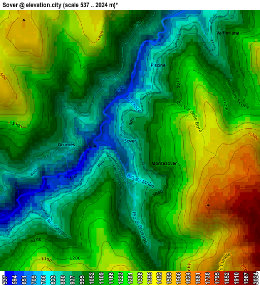
Below is the Elevation map of Sover, which displays elevation range with different colors. Scale of the first map is from 537 to 2024 m (1762 to 6640 ft) with average elevation of 1136.6 meters (=3729 ft) [note 1]
These maps also provides idea of topography and contour of this city, they are displayed at different zoom levels. More info about maps, scale and edge coordinates you can find below images.
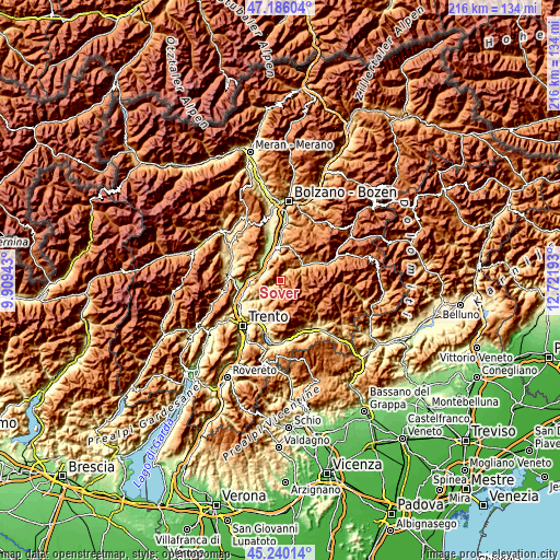
| \ | Map #1 | Topo.Map |
| Scale [m] | 537..2024 m | × |
| Scale [ft] | 1762..6640 ft | × |
| Average | 1136.6 m = 3729 ft | × |
| Width | 6.76 km = 4.2 mi | 216.4 km = 134.5 mi |
| Height | 6.76 km = 4.2 mi | 216.4 km = 134.5 mi |
| ↑Max Latitude | 46.252106° | 47.18604° |
| Latitude at center | 46.22171° | 46.22171° |
| ↓Min Latitude | 46.191297° | 45.24014° |
| ← Min Longitude | 11.271735° | 9.90943° |
| Longitude center | 11.31568° | 11.31568° |
| →Max Longitude | 11.359625° | 12.72193° |
Nearby cities:
Cities around Sover sort by population:
• Salorno elevation 214 m
8.3 km,  284°
284°
• Cembra 661 m
8.9 km,  234°
234°
• Laghetti 215 m
8.3 km,  315°
315°
• Segonzano 721 m
5.5 km, 230°
• Faver 684 m
7.5 km, 233°
• Valfloriana 845 m
3.8 km,  34°
34°
• Capriana 1002 m
4.9 km,  20°
20°
• Grumes 855 m
1.7 km,  267°
267°
• Anterivo 1221 m
7.4 km, 32°
• Valda 790 m
4.2 km,  247°
247°
• Centrale 1075 m
6.8 km,  188°
188°
• Grauno 947 m
1.6 km,  305°
305°
Multilingual:
 En español:
Sover elevación 842 m.
 En France:
Sover élévation 842 m.


Sources and notes:
- [note 1] Map square and city borders are not equal. Map elevation data is calculated only from area inside that square.
- [src 1] Elevation data from geonames database provided with same terms of usage.
- [src 2] The elevation map of Sover is generated using elevation data from NASA's 3 arcsec (90m) resolution SRTM data.
- [src 3] Base (background) map © OpenStreetMap contributors tiles are generated by Geofabrik and OpenTopoMap.
Copyright & License:
This Sover Elevation Map is licensed under CC BY-SA. You may reuse any part from this page, if you give a proper credit by linking to this URL:
 More info on terms of use page.