Centrale elevation
Centrale (Trentino-Alto Adige, Provincia autonoma di Trento), Italy elevation is 1075 meters and Centrale elevation in feet is 3527 ft above sea level [src 1]. Centrale is a seat of a third-order administrative division (feature code) with elevation that is 753 meters (2470 ft) bigger than average city elevation in Italy.
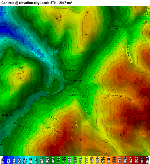
Below is the Elevation map of Centrale, which displays elevation range with different colors. Scale of the first map is from 570 to 2047 m (1870 to 6716 ft) with average elevation of 1342.4 meters (=4404 ft) [note 1]
These maps also provides idea of topography and contour of this city, they are displayed at different zoom levels. More info about maps, scale and edge coordinates you can find below images.
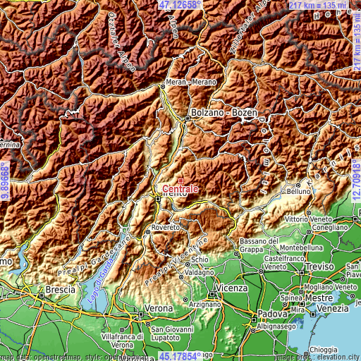
| \ | Map #1 | Topo.Map |
| Scale [m] | 570..2047 m | × |
| Scale [ft] | 1870..6716 ft | × |
| Average | 1342.4 m = 4404 ft | × |
| Width | 6.77 km = 4.2 mi | 216.6 km = 134.6 mi |
| Height | 6.77 km = 4.2 mi | 216.6 km = 134.6 mi |
| ↑Max Latitude | 46.19161° | 47.12658° |
| Latitude at center | 46.16118° | 46.16118° |
| ↓Min Latitude | 46.130734° | 45.17854° |
| ← Min Longitude | 11.258985° | 9.89668° |
| Longitude center | 11.30293° | 11.30293° |
| →Max Longitude | 11.346875° | 12.70918° |
Nearby cities:
Cities around Centrale sort by population:
• Baselga di Pinè elevation 961 m
5.4 km,  233°
233°
• Cembra 661 m
6.4 km,  283°
283°
• Miola di Pinè 998 m
5.7 km, 227°
• Sant'Orsola Terme 951 m
5.8 km,  180°
180°
• Segonzano 721 m
4.6 km,  314°
314°
• Faver 684 m
5.5 km,  293°
293°
• Lona-Lases 635 m
6.7 km,  253°
253°
• Lases 638 m
6.7 km, 254°
• Fierozzo 1122 m
5.7 km,  167°
167°
• Sant'Orsola 957 m
5.8 km, 180°
• Valda 790 m
5.9 km,  330°
330°
• Palù del Fersina 1335 m
5.1 km,  133°
133°
Multilingual:
 En español:
Centrale elevación 1075 m.
 En France:
Centrale élévation 1075 m.
 Auf Deutsch:
Centrale höhe über dem Meeresspiegel ist 1075 m.

Sources and notes:
- [note 1] Map square and city borders are not equal. Map elevation data is calculated only from area inside that square.
- [src 1] Elevation data from geonames database provided with same terms of usage.
- [src 2] The elevation map of Centrale is generated using elevation data from NASA's 3 arcsec (90m) resolution SRTM data.
- [src 3] Base (background) map © OpenStreetMap contributors tiles are generated by Geofabrik and OpenTopoMap.
Copyright & License:
This Centrale Elevation Map is licensed under CC BY-SA. You may reuse any part from this page, if you give a proper credit by linking to this URL:
 More info on terms of use page.