Vallarsa elevation
Vallarsa (Trentino-Alto Adige, Provincia autonoma di Trento), Italy elevation is 726 meters and Vallarsa elevation in feet is 2382 ft above sea level [src 1]. Vallarsa is a seat of a third-order administrative division (feature code) with elevation that is 404 meters (1325 ft) bigger than average city elevation in Italy.
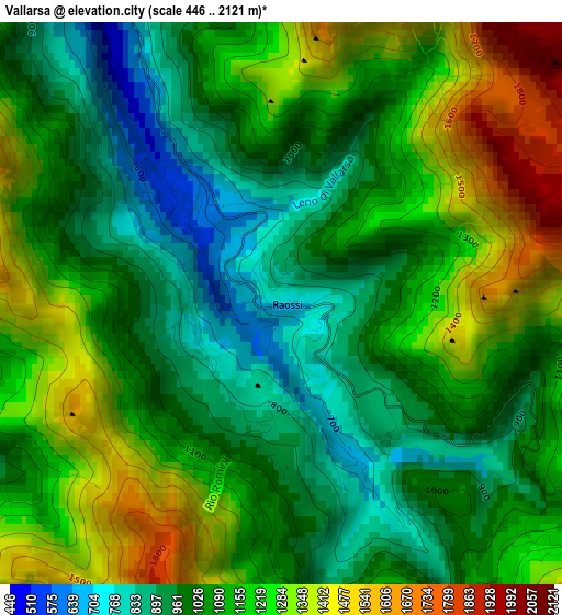
Below is the Elevation map of Vallarsa, which displays elevation range with different colors. Scale of the first map is from 446 to 2121 m (1463 to 6959 ft) with average elevation of 1116.5 meters (=3663 ft) [note 1]
These maps also provides idea of topography and contour of this city, they are displayed at different zoom levels. More info about maps, scale and edge coordinates you can find below images.
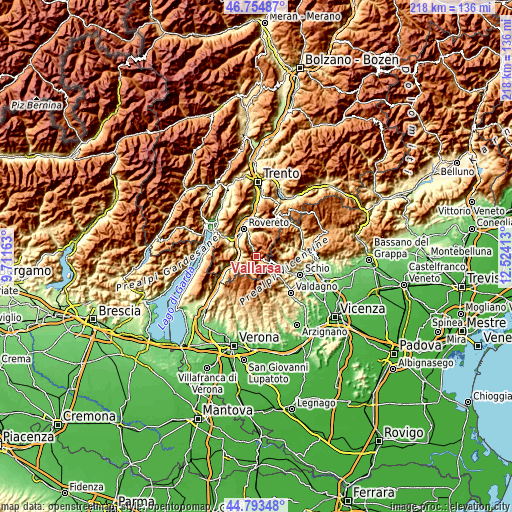
| \ | Map #1 | Topo.Map |
| Scale [m] | 446..2121 m | × |
| Scale [ft] | 1463..6959 ft | × |
| Average | 1116.5 m = 3663 ft | × |
| Width | 6.82 km = 4.2 mi | 218.1 km = 135.5 mi |
| Height | 6.82 km = 4.2 mi | 218.1 km = 135.5 mi |
| ↑Max Latitude | 45.813438° | 46.75487° |
| Latitude at center | 45.7828° | 45.7828° |
| ↓Min Latitude | 45.752145° | 44.79348° |
| ← Min Longitude | 11.073935° | 9.71163° |
| Longitude center | 11.11788° | 11.11788° |
| →Max Longitude | 11.161825° | 12.52413° |
Nearby cities:
Cities around Vallarsa sort by population:
• Mori elevation 204 m
13.1 km,  305°
305°
• Ala 171 m
9.1 km,  254°
254°
• Recoaro Terme 456 m
11.9 km,  137°
137°
• Marco 173 m
10.7 km, 308°
• Brentonico 701 m
13.2 km,  287°
287°
• Trambileno 515 m
10.2 km,  340°
340°
• Valli del Pasubio 339 m
12.2 km,  112°
112°
• Terragnolo 788 m
11 km,  15°
15°
• Moscheri 520 m
10.1 km, 340°
• Piazza 768 m
10.9 km, 16°
• Posina 543 m
11.2 km,  85°
85°
• Laghi 564 m
12.8 km,  68°
68°
Multilingual:
 En español:
Vallarsa elevación 726 m.
 En France:
Vallarsa élévation 726 m.
 Auf Deutsch:
Vallarsa höhe über dem Meeresspiegel ist 726 m.

Sources and notes:
- [note 1] Map square and city borders are not equal. Map elevation data is calculated only from area inside that square.
- [src 1] Elevation data from geonames database provided with same terms of usage.
- [src 2] The elevation map of Vallarsa is generated using elevation data from NASA's 3 arcsec (90m) resolution SRTM data.
- [src 3] Base (background) map © OpenStreetMap contributors tiles are generated by Geofabrik and OpenTopoMap.
Copyright & License:
This Vallarsa Elevation Map is licensed under CC BY-SA. You may reuse any part from this page, if you give a proper credit by linking to this URL:
 More info on terms of use page.