Ponteranica elevation
Ponteranica (Lombardy, Provincia di Bergamo), Italy elevation is 328 meters and Ponteranica elevation in feet is 1076 ft above sea level [src 1]. Ponteranica is a seat of a third-order administrative division (feature code) with elevation that is 6 meters (20 ft) bigger than average city elevation in Italy.
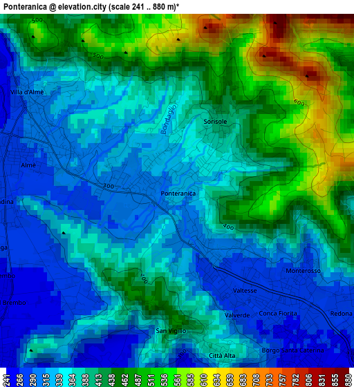
Below is the Elevation map of Ponteranica, which displays elevation range with different colors. Scale of the first map is from 241 to 880 m (791 to 2887 ft) with average elevation of 390.4 meters (=1281 ft) [note 1]
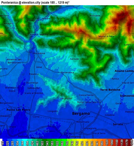
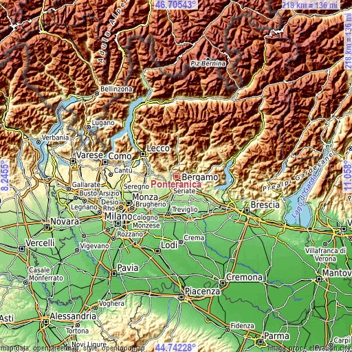
These maps also provides idea of topography and contour of this city, they are displayed at different zoom levels. More info about maps, scale and edge coordinates you can find below images.
| \ | Map #1 | Map #2 | Topo.Map |
| Scale [m] | 241..880 m | 185..1219 m | × |
| Scale [ft] | 791..2887 ft | 607..3999 ft | × |
| Average | 390.4 m = 1281 ft | 399.7 m = 1311 ft | × |
| Width | 6.82 km = 4.2 mi | 13.64 km = 8.5 mi | 218.3 km = 135.6 mi |
| Height | 6.82 km = 4.2 mi | 13.64 km = 8.5 mi | 218.3 km = 135.6 mi |
| ↑Max Latitude | 45.763146° | 45.793795° | 46.70543° |
| Latitude at center | 45.73248° | 45.73248° | 45.73248° |
| ↓Min Latitude | 45.701797° | 45.671098° | 44.74228° |
| ← Min Longitude | 9.607805° | 9.563859° | 8.2455° |
| Longitude center | 9.65175° | 9.65175° | 9.65175° |
| →Max Longitude | 9.695695° | 9.739641° | 11.058° |
Nearby cities:
Cities around Ponteranica sort by population:
• Bergamo elevation 260 m
4.2 km,  163°
163°
• Ponte San Pietro 231 m
5.6 km,  238°
238°
• Sorisole 298 m
1.1 km,  263°
263°
• Torre Boldone 286 m
4.7 km,  111°
111°
• Mozzo 254 m
5 km,  221°
221°
• Villa d'Almè 301 m
3.2 km,  303°
303°
• Ranica 287 m
4.9 km,  102°
102°
• Almenno San Salvatore 295 m
4.7 km,  294°
294°
• Almè 290 m
2.9 km,  284°
284°
• Almenno San Bartolomeo 292 m
5.6 km, 277°
• Paladina 276 m
3.6 km,  266°
266°
• Scano al Brembo 266 m
3.7 km,  245°
245°
Multilingual:
 En español:
Ponteranica elevación 328 m.
 En France:
Ponteranica élévation 328 m.
 Auf Deutsch:
Ponteranica höhe über dem Meeresspiegel ist 328 m.

Sources and notes:
- [note 1] Map square and city borders are not equal. Map elevation data is calculated only from area inside that square.
- [src 1] Elevation data from geonames database provided with same terms of usage.
- [src 2] The elevation map of Ponteranica is generated using elevation data from NASA's 3 arcsec (90m) resolution SRTM data.
- [src 3] Base (background) map © OpenStreetMap contributors tiles are generated by Geofabrik and OpenTopoMap.
Copyright & License:
This Ponteranica Elevation Map is licensed under CC BY-SA. You may reuse any part from this page, if you give a proper credit by linking to this URL:
 More info on terms of use page.