Pognano elevation
Pognano (Lombardy, Provincia di Bergamo), Italy elevation is 157 meters and Pognano elevation in feet is 515 ft above sea level [src 1]. Pognano is a seat of a third-order administrative division (feature code) with elevation that is 165 meters (541 ft) smaller than average city elevation in Italy.
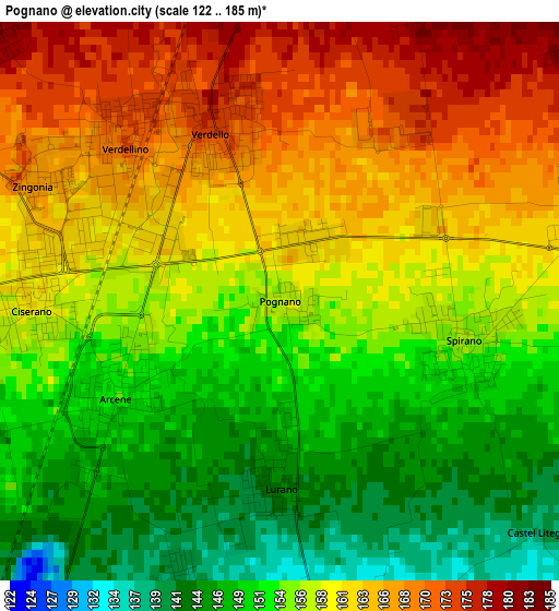
Below is the Elevation map of Pognano, which displays elevation range with different colors. Scale of the first map is from 122 to 185 m (400 to 607 ft) with average elevation of 157.3 meters (=516 ft) [note 1]
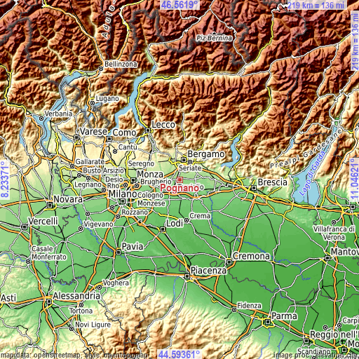
These maps also provides idea of topography and contour of this city, they are displayed at different zoom levels. More info about maps, scale and edge coordinates you can find below images.
| \ | Map #1 | Topo.Map |
| Scale [m] | 122..185 m | × |
| Scale [ft] | 400..607 ft | × |
| Average | 157.3 m = 516 ft | × |
| Width | 6.84 km = 4.3 mi | 218.9 km = 136 mi |
| Height | 6.84 km = 4.3 mi | 218.8 km = 136 mi |
| ↑Max Latitude | 45.617126° | 46.5619° |
| Latitude at center | 45.58638° | 45.58638° |
| ↓Min Latitude | 45.555617° | 44.59361° |
| ← Min Longitude | 9.596015° | 8.23371° |
| Longitude center | 9.63996° | 9.63996° |
| →Max Longitude | 9.683905° | 11.04621° |
Nearby cities:
Cities around Pognano sort by population:
• Urgnano elevation 173 m
4.5 km,  71°
71°
• Verdellino 164 m
3 km,  303°
303°
• Verdello 169 m
2.1 km,  335°
335°
• Brignano Gera d'Adda 130 m
4.8 km,  176°
176°
• Ciserano 160 m
3 km,  273°
273°
• Boltiere 172 m
5.1 km,  288°
288°
• Spirano 155 m
2.3 km,  103°
103°
• Arcene 153 m
2.2 km,  242°
242°
• Comun Nuovo 189 m
4.4 km,  22°
22°
• Levate 186 m
4.5 km, 344°
• Castel Rozzone 139 m
4.1 km,  202°
202°
• Lurano 144 m
2.3 km, 179°
Multilingual:
 En español:
Pognano elevación 157 m.
 En France:
Pognano élévation 157 m.


Sources and notes:
- [note 1] Map square and city borders are not equal. Map elevation data is calculated only from area inside that square.
- [src 1] Elevation data from geonames database provided with same terms of usage.
- [src 2] The elevation map of Pognano is generated using elevation data from NASA's 3 arcsec (90m) resolution SRTM data.
- [src 3] Base (background) map © OpenStreetMap contributors tiles are generated by Geofabrik and OpenTopoMap.
Copyright & License:
This Pognano Elevation Map is licensed under CC BY-SA. You may reuse any part from this page, if you give a proper credit by linking to this URL:
 More info on terms of use page.