Plesio elevation
Plesio (Lombardy, Provincia di Como), Italy elevation is 622 meters and Plesio elevation in feet is 2041 ft above sea level [src 1]. Plesio is a seat of a third-order administrative division (feature code) with elevation that is 300 meters (984 ft) bigger than average city elevation in Italy.
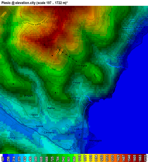
Below is the Elevation map of Plesio, which displays elevation range with different colors. Scale of the first map is from 197 to 1722 m (646 to 5650 ft) with average elevation of 638.7 meters (=2095 ft) [note 1]
These maps also provides idea of topography and contour of this city, they are displayed at different zoom levels. More info about maps, scale and edge coordinates you can find below images.
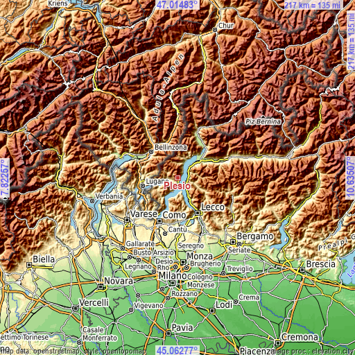
| \ | Map #1 | Topo.Map |
| Scale [m] | 197..1722 m | × |
| Scale [ft] | 646..5650 ft | × |
| Average | 638.7 m = 2095 ft | × |
| Width | 6.78 km = 4.2 mi | 217 km = 134.8 mi |
| Height | 6.78 km = 4.2 mi | 217 km = 134.8 mi |
| ↑Max Latitude | 46.077912° | 47.01483° |
| Latitude at center | 46.04742° | 46.04742° |
| ↓Min Latitude | 46.016911° | 45.06277° |
| ← Min Longitude | 9.184875° | 7.82257° |
| Longitude center | 9.22882° | 9.22882° |
| →Max Longitude | 9.272765° | 10.63507° |
Nearby cities:
Cities around Plesio sort by population:
• Menaggio elevation 207 m
3.1 km,  165°
165°
• Bellano 274 m
6.1 km,  93°
93°
• Carlazzo 304 m
5 km,  263°
263°
• San Siro 208 m
3.7 km,  56°
56°
• Grandola ed Uniti 388 m
2.8 km,  206°
206°
• Codogna-Cardano 398 m
2.6 km, 213°
• Varenna 275 m
5.9 km,  133°
133°
• Cremia 345 m
5.4 km,  36°
36°
• Griante 240 m
5.8 km, 174°
• Perledo 433 m
6.3 km,  124°
124°
• Vignola 297 m
5.7 km, 37°
• Bene Lario 381 m
4 km,  239°
239°
Multilingual:
 En español:
Plesio elevación 622 m.
 En France:
Plesio élévation 622 m.


Sources and notes:
- [note 1] Map square and city borders are not equal. Map elevation data is calculated only from area inside that square.
- [src 1] Elevation data from geonames database provided with same terms of usage.
- [src 2] The elevation map of Plesio is generated using elevation data from NASA's 3 arcsec (90m) resolution SRTM data.
- [src 3] Base (background) map © OpenStreetMap contributors tiles are generated by Geofabrik and OpenTopoMap.
Copyright & License:
This Plesio Elevation Map is licensed under CC BY-SA. You may reuse any part from this page, if you give a proper credit by linking to this URL:
 More info on terms of use page.