Vignola elevation
Vignola (Lombardy, Provincia di Como), Italy elevation is 297 meters and Vignola elevation in feet is 974 ft above sea level [src 1]. Vignola is a seat of a third-order administrative division (feature code) with elevation that is 25 meters (82 ft) smaller than average city elevation in Italy.
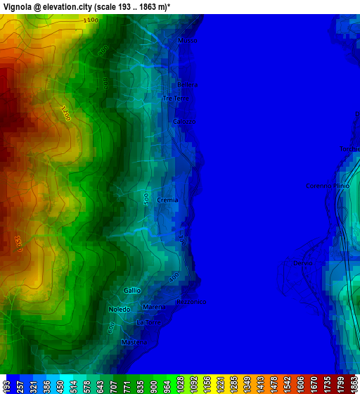
Below is the Elevation map of Vignola, which displays elevation range with different colors. Scale of the first map is from 193 to 1863 m (633 to 6112 ft) with average elevation of 543.7 meters (=1784 ft) [note 1]
These maps also provides idea of topography and contour of this city, they are displayed at different zoom levels. More info about maps, scale and edge coordinates you can find below images.
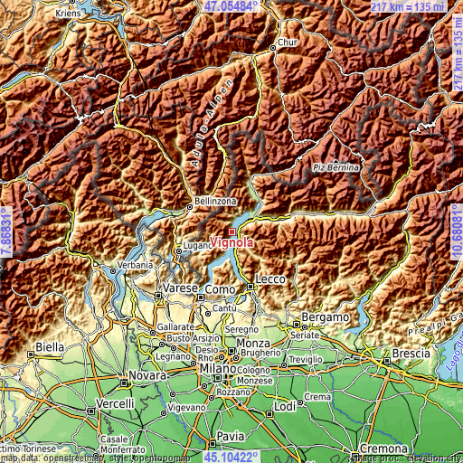
| \ | Map #1 | Topo.Map |
| Scale [m] | 193..1863 m | × |
| Scale [ft] | 633..6112 ft | × |
| Average | 543.7 m = 1784 ft | × |
| Width | 6.78 km = 4.2 mi | 216.9 km = 134.8 mi |
| Height | 6.78 km = 4.2 mi | 216.9 km = 134.8 mi |
| ↑Max Latitude | 46.11862° | 47.05484° |
| Latitude at center | 46.08815° | 46.08815° |
| ↓Min Latitude | 46.057663° | 45.10422° |
| ← Min Longitude | 9.230615° | 7.86831° |
| Longitude center | 9.27456° | 9.27456° |
| →Max Longitude | 9.318505° | 10.68081° |
Nearby cities:
Cities around Vignola sort by population:
• Dongo elevation 218 m
4.7 km,  6°
6°
• Bellano 274 m
5.5 km,  152°
152°
• Dervio 219 m
2.8 km,  116°
116°
• San Siro 208 m
2.5 km,  190°
190°
• Pianello del Lario 218 m
1.6 km, 6°
• Calozzo 227 m
1.4 km,  2°
2°
• Musso 259 m
2.8 km,  358°
358°
• Cremia 345 m
0.3 km,  235°
235°
• Dorio 253 m
3.7 km,  68°
68°
• Vestreno 558 m
3.9 km,  97°
97°
• Sueglio 761 m
4.6 km,  93°
93°
• Introzzo 666 m
5.2 km, 98°
Multilingual:
 En español:
Vignola elevación 297 m.
 En France:
Vignola élévation 297 m.


Sources and notes:
- [note 1] Map square and city borders are not equal. Map elevation data is calculated only from area inside that square.
- [src 1] Elevation data from geonames database provided with same terms of usage.
- [src 2] The elevation map of Vignola is generated using elevation data from NASA's 3 arcsec (90m) resolution SRTM data.
- [src 3] Base (background) map © OpenStreetMap contributors tiles are generated by Geofabrik and OpenTopoMap.
Copyright & License:
This Vignola Elevation Map is licensed under CC BY-SA. You may reuse any part from this page, if you give a proper credit by linking to this URL:
 More info on terms of use page.