Orino elevation
Orino (Lombardy, Provincia di Varese), Italy elevation is 447 meters and Orino elevation in feet is 1467 ft above sea level [src 1]. Orino is a seat of a third-order administrative division (feature code) with elevation that is 125 meters (410 ft) bigger than average city elevation in Italy.
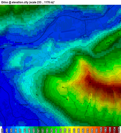
Below is the Elevation map of Orino, which displays elevation range with different colors. Scale of the first map is from 233 to 1170 m (764 to 3839 ft) with average elevation of 472.1 meters (=1549 ft) [note 1]
These maps also provides idea of topography and contour of this city, they are displayed at different zoom levels. More info about maps, scale and edge coordinates you can find below images.
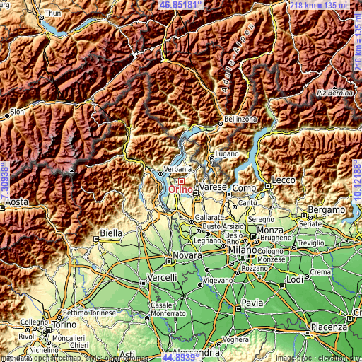
| \ | Map #1 | Topo.Map |
| Scale [m] | 233..1170 m | × |
| Scale [ft] | 764..3839 ft | × |
| Average | 472.1 m = 1549 ft | × |
| Width | 6.8 km = 4.2 mi | 217.7 km = 135.3 mi |
| Height | 6.8 km = 4.2 mi | 217.7 km = 135.3 mi |
| ↑Max Latitude | 45.912064° | 46.85181° |
| Latitude at center | 45.88148° | 45.88148° |
| ↓Min Latitude | 45.850879° | 44.8939° |
| ← Min Longitude | 8.671685° | 7.30938° |
| Longitude center | 8.71563° | 8.71563° |
| →Max Longitude | 8.759575° | 10.12188° |
Nearby cities:
Cities around Orino sort by population:
• Cocquio elevation 279 m
3 km,  225°
225°
• Cittiglio 247 m
4.2 km,  292°
292°
• Cuveglio 297 m
3.1 km,  26°
26°
• Gemonio 309 m
3.2 km,  264°
264°
• Caravate 255 m
4.8 km,  266°
266°
• Comerio 390 m
4.9 km,  155°
155°
• Brenta 283 m
2.8 km,  299°
299°
• Cuvio 304 m
2.2 km,  41°
41°
• Casalzuigno 319 m
2.7 km,  348°
348°
• Azzio 382 m
0.7 km, 302°
• Castello Cabiaglio 520 m
3.5 km,  67°
67°
• Duno 547 m
4 km, 25°
Multilingual:
 En español:
Orino elevación 447 m.
 En France:
Orino élévation 447 m.


Sources and notes:
- [note 1] Map square and city borders are not equal. Map elevation data is calculated only from area inside that square.
- [src 1] Elevation data from geonames database provided with same terms of usage.
- [src 2] The elevation map of Orino is generated using elevation data from NASA's 3 arcsec (90m) resolution SRTM data.
- [src 3] Base (background) map © OpenStreetMap contributors tiles are generated by Geofabrik and OpenTopoMap.
Copyright & License:
This Orino Elevation Map is licensed under CC BY-SA. You may reuse any part from this page, if you give a proper credit by linking to this URL:
 More info on terms of use page.