Gemonio elevation
Gemonio (Lombardy, Provincia di Varese), Italy elevation is 309 meters and Gemonio elevation in feet is 1014 ft above sea level [src 1]. Gemonio is a seat of a third-order administrative division (feature code) with elevation that is 13 meters (43 ft) smaller than average city elevation in Italy.
Below is the Elevation map of Gemonio, which displays elevation range with different colors. Scale of the first map is from 201 to 877 m (659 to 2877 ft) with average elevation of 330.7 meters (=1085 ft) [note 1]
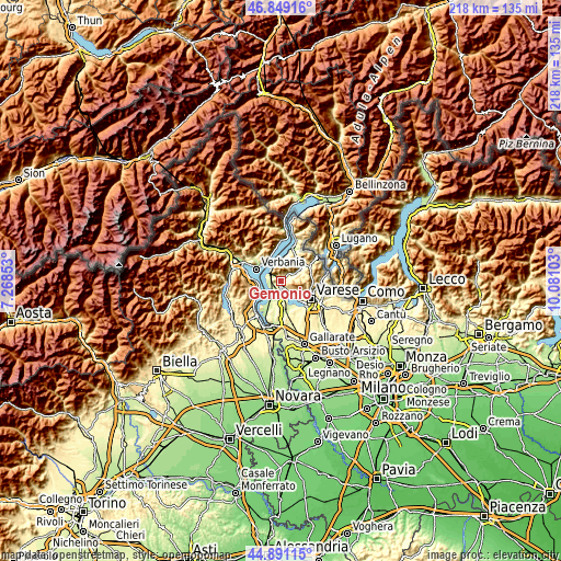
These maps also provides idea of topography and contour of this city, they are displayed at different zoom levels. More info about maps, scale and edge coordinates you can find below images.
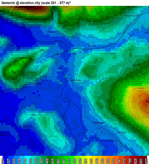
| \ | Map #1 | Topo.Map |
| Scale [m] | 201..877 m | × |
| Scale [ft] | 659..2877 ft | × |
| Average | 330.7 m = 1085 ft | × |
| Width | 6.8 km = 4.2 mi | 217.7 km = 135.3 mi |
| Height | 6.8 km = 4.2 mi | 217.7 km = 135.3 mi |
| ↑Max Latitude | 45.909365° | 46.84916° |
| Latitude at center | 45.87878° | 45.87878° |
| ↓Min Latitude | 45.848178° | 44.89115° |
| ← Min Longitude | 8.630835° | 7.26853° |
| Longitude center | 8.67478° | 8.67478° |
| →Max Longitude | 8.718725° | 10.08103° |
Nearby cities:
Cities around Gemonio sort by population:
• Besozzo elevation 281 m
3.4 km,  192°
192°
• Cocquio 279 m
2.1 km,  149°
149°
• Cittiglio 247 m
2 km,  339°
339°
• Leggiuno 243 m
4.2 km,  265°
265°
• Caravate 255 m
1.6 km, 269°
• Monvalle 234 m
4.1 km,  235°
235°
• Brenta 283 m
1.8 km,  22°
22°
• Sangiano 233 m
3.2 km,  262°
262°
• Cuvio 304 m
5 km,  67°
67°
• Casalzuigno 319 m
3.9 km,  42°
42°
• Azzio 382 m
2.7 km,  75°
75°
• Orino 447 m
3.2 km, 84°
Multilingual:
 En español:
Gemonio elevación 309 m.
 En France:
Gemonio élévation 309 m.


Sources and notes:
- [note 1] Map square and city borders are not equal. Map elevation data is calculated only from area inside that square.
- [src 1] Elevation data from geonames database provided with same terms of usage.
- [src 2] The elevation map of Gemonio is generated using elevation data from NASA's 3 arcsec (90m) resolution SRTM data.
- [src 3] Base (background) map © OpenStreetMap contributors tiles are generated by Geofabrik and OpenTopoMap.
Copyright & License:
This Gemonio Elevation Map is licensed under CC BY-SA. You may reuse any part from this page, if you give a proper credit by linking to this URL:
 More info on terms of use page.