Scagnello elevation
Scagnello (Piedmont, Provincia di Cuneo), Italy elevation is 743 meters and Scagnello elevation in feet is 2438 ft above sea level [src 1]. Scagnello is a seat of a third-order administrative division (feature code) with elevation that is 421 meters (1381 ft) bigger than average city elevation in Italy.
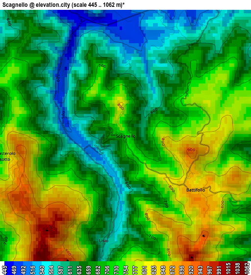
Below is the Elevation map of Scagnello, which displays elevation range with different colors. Scale of the first map is from 445 to 1062 m (1460 to 3484 ft) with average elevation of 699.7 meters (=2296 ft) [note 1]
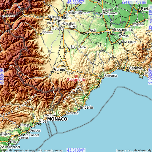
These maps also provides idea of topography and contour of this city, they are displayed at different zoom levels. More info about maps, scale and edge coordinates you can find below images.
| \ | Map #1 | Topo.Map |
| Scale [m] | 445..1062 m | × |
| Scale [ft] | 1460..3484 ft | × |
| Average | 699.7 m = 2296 ft | × |
| Width | 6.99 km = 4.3 mi | 223.7 km = 139 mi |
| Height | 6.99 km = 4.3 mi | 223.7 km = 139 mi |
| ↑Max Latitude | 44.364755° | 45.33057° |
| Latitude at center | 44.33333° | 44.33333° |
| ↓Min Latitude | 44.301888° | 43.31884° |
| ← Min Longitude | 7.942495° | 6.58019° |
| Longitude center | 7.98644° | 7.98644° |
| →Max Longitude | 8.030385° | 9.39269° |
Nearby cities:
Cities around Scagnello sort by population:
• Ceva elevation 381 m
6.6 km,  29°
29°
• San Michele Mondovì 449 m
7.8 km,  307°
307°
• Bagnasco 488 m
5.7 km,  124°
124°
• Torre Mondovì 465 m
7.2 km,  287°
287°
• Lesegno 417 m
7.7 km,  349°
349°
• Mombasiglio 527 m
4 km,  338°
338°
• Nucetto 457 m
5.9 km,  83°
83°
• Battifollo 853 m
2.5 km,  127°
127°
• Lisio 589 m
3 km,  191°
191°
• Viola 850 m
5 km,  199°
199°
• Massimino 535 m
7.7 km, 119°
• Monasterolo Casotto 765 m
3.5 km,  260°
260°
Multilingual:
 En español:
Scagnello elevación 743 m.
 En France:
Scagnello élévation 743 m.
 Auf Deutsch:
Scagnello höhe über dem Meeresspiegel ist 743 m.

Sources and notes:
- [note 1] Map square and city borders are not equal. Map elevation data is calculated only from area inside that square.
- [src 1] Elevation data from geonames database provided with same terms of usage.
- [src 2] The elevation map of Scagnello is generated using elevation data from NASA's 3 arcsec (90m) resolution SRTM data.
- [src 3] Base (background) map © OpenStreetMap contributors tiles are generated by Geofabrik and OpenTopoMap.
Copyright & License:
This Scagnello Elevation Map is licensed under CC BY-SA. You may reuse any part from this page, if you give a proper credit by linking to this URL:
 More info on terms of use page.