Bellizzi elevation
Bellizzi (Campania, Provincia di Salerno), Italy elevation is 62 meters and Bellizzi elevation in feet is 203 ft above sea level [src 1]. Bellizzi is a seat of a third-order administrative division (feature code) with elevation that is 260 meters (853 ft) smaller than average city elevation in Italy.
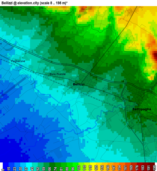
Below is the Elevation map of Bellizzi, which displays elevation range with different colors. Scale of the first map is from 8 to 198 m (26 to 650 ft) with average elevation of 59.3 meters (=195 ft) [note 1]
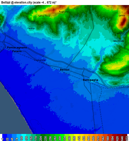
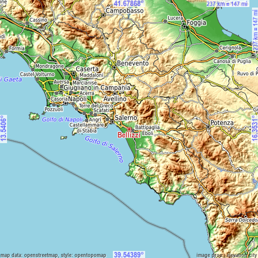
These maps also provides idea of topography and contour of this city, they are displayed at different zoom levels. More info about maps, scale and edge coordinates you can find below images.
| \ | Map #1 | Map #2 | Topo.Map |
| Scale [m] | 8..198 m | -4..672 m | × |
| Scale [ft] | 26..650 ft | -13..2205 ft | × |
| Average | 59.3 m = 195 ft | 101.7 m = 334 ft | × |
| Width | 7.42 km = 4.6 mi | 14.84 km = 9.2 mi | 237.4 km = 147.5 mi |
| Height | 7.42 km = 4.6 mi | 14.84 km = 9.2 mi | 237.4 km = 147.5 mi |
| ↑Max Latitude | 40.653158° | 40.68649° | 41.67868° |
| Latitude at center | 40.61981° | 40.61981° | 40.61981° |
| ↓Min Latitude | 40.586445° | 40.553064° | 39.54389° |
| ← Min Longitude | 14.902905° | 14.858959° | 13.5406° |
| Longitude center | 14.94685° | 14.94685° | 14.94685° |
| →Max Longitude | 14.990795° | 15.034741° | 16.3531° |
Nearby cities:
Cities around Bellizzi sort by population:
• Battipaglia elevation 78 m
3.2 km,  112°
112°
• Pontecagnano 34 m
6.6 km,  294°
294°
• Montecorvino Pugliano 363 m
6.6 km,  358°
358°
• Olevano sul Tusciano 191 m
7.7 km,  57°
57°
• Sant'Antonio 33 m
4.5 km, 294°
• Faiano 148 m
6.1 km,  321°
321°
• Monticelli 143 m
6.8 km, 60°
• Pratole 50 m
1.9 km, 290°
• Macchia 138 m
4.6 km,  35°
35°
• Pagliarone 45 m
3.1 km, 291°
• Santa Tecla-Castelpagano 306 m
6.4 km,  337°
337°
• Pugliano 357 m
6.6 km, 358°
Multilingual:
 En español:
Bellizzi elevación 62 m.
 En France:
Bellizzi élévation 62 m.


Sources and notes:
- [note 1] Map square and city borders are not equal. Map elevation data is calculated only from area inside that square.
- [src 1] Elevation data from geonames database provided with same terms of usage.
- [src 2] The elevation map of Bellizzi is generated using elevation data from NASA's 3 arcsec (90m) resolution SRTM data.
- [src 3] Base (background) map © OpenStreetMap contributors tiles are generated by Geofabrik and OpenTopoMap.
Copyright & License:
This Bellizzi Elevation Map is licensed under CC BY-SA. You may reuse any part from this page, if you give a proper credit by linking to this URL:
 More info on terms of use page.