Abbateggio elevation
Abbateggio (Abruzzo, Provincia di Pescara), Italy elevation is 471 meters and Abbateggio elevation in feet is 1545 ft above sea level [src 1]. Abbateggio is a seat of a third-order administrative division (feature code) with elevation that is 149 meters (489 ft) bigger than average city elevation in Italy.
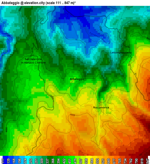
Below is the Elevation map of Abbateggio, which displays elevation range with different colors. Scale of the first map is from 111 to 847 m (364 to 2779 ft) with average elevation of 436.8 meters (=1433 ft) [note 1]
These maps also provides idea of topography and contour of this city, they are displayed at different zoom levels. More info about maps, scale and edge coordinates you can find below images.
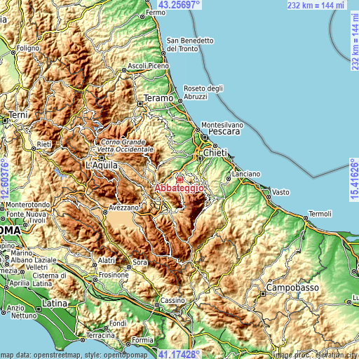
| \ | Map #1 | Topo.Map |
| Scale [m] | 111..847 m | × |
| Scale [ft] | 364..2779 ft | × |
| Average | 436.8 m = 1433 ft | × |
| Width | 7.24 km = 4.5 mi | 231.6 km = 143.9 mi |
| Height | 7.24 km = 4.5 mi | 231.6 km = 143.9 mi |
| ↑Max Latitude | 42.256744° | 43.25697° |
| Latitude at center | 42.22421° | 42.22421° |
| ↓Min Latitude | 42.191659° | 41.17428° |
| ← Min Longitude | 13.966065° | 12.60376° |
| Longitude center | 14.01001° | 14.01001° |
| →Max Longitude | 14.053955° | 15.41626° |
Nearby cities:
Cities around Abbateggio sort by population:
• Torre de' Passeri elevation 172 m
6.7 km,  288°
288°
• Lettomanoppello 337 m
3.2 km,  47°
47°
• Scafa 120 m
4.7 km,  346°
346°
• Tocco da Casauria 323 m
7.9 km,  260°
260°
• San Valentino in Abruzzo Citeriore 455 m
2.2 km,  296°
296°
• Caramanico Terme 629 m
7.6 km,  183°
183°
• Manoppello 234 m
5.7 km, 46°
• Roccamorice 540 m
1.8 km,  135°
135°
• Serramonacesca 292 m
7.3 km,  68°
68°
• Salle 471 m
6.6 km,  217°
217°
• Bolognano 297 m
4.2 km, 260°
• Turrivalignani 304 m
4.6 km,  19°
19°
Multilingual:
 En español:
Abbateggio elevación 471 m.
 En France:
Abbateggio élévation 471 m.
 Auf Deutsch:
Abbateggio höhe über dem Meeresspiegel ist 471 m.

Sources and notes:
- [note 1] Map square and city borders are not equal. Map elevation data is calculated only from area inside that square.
- [src 1] Elevation data from geonames database provided with same terms of usage.
- [src 2] The elevation map of Abbateggio is generated using elevation data from NASA's 3 arcsec (90m) resolution SRTM data.
- [src 3] Base (background) map © OpenStreetMap contributors tiles are generated by Geofabrik and OpenTopoMap.
Copyright & License:
This Abbateggio Elevation Map is licensed under CC BY-SA. You may reuse any part from this page, if you give a proper credit by linking to this URL:
 More info on terms of use page.