Manoppello elevation
Manoppello (Abruzzo, Provincia di Pescara), Italy elevation is 234 meters and Manoppello elevation in feet is 768 ft above sea level [src 1]. Manoppello is a seat of a third-order administrative division (feature code) with elevation that is 88 meters (289 ft) smaller than average city elevation in Italy.
Below is the Elevation map of Manoppello, which displays elevation range with different colors. Scale of the first map is from 69 to 849 m (226 to 2785 ft) with average elevation of 283.7 meters (=931 ft) [note 1]
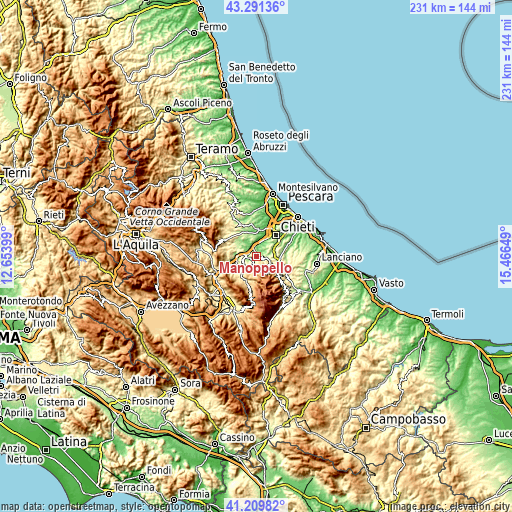
These maps also provides idea of topography and contour of this city, they are displayed at different zoom levels. More info about maps, scale and edge coordinates you can find below images.
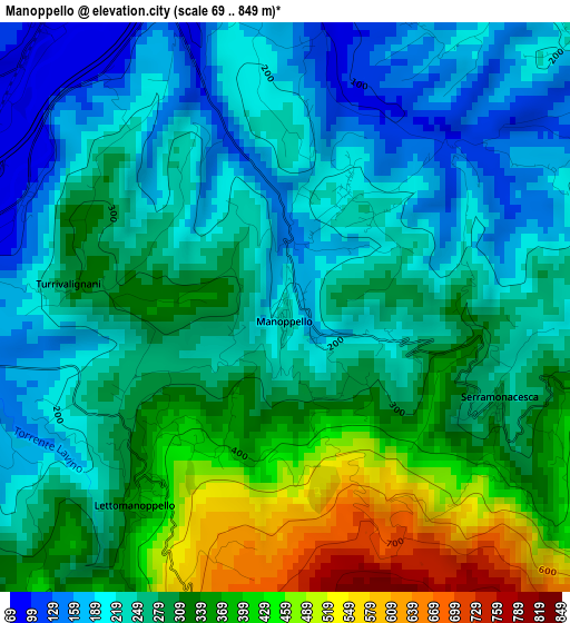
| \ | Map #1 | Topo.Map |
| Scale [m] | 69..849 m | × |
| Scale [ft] | 226..2785 ft | × |
| Average | 283.7 m = 931 ft | × |
| Width | 7.23 km = 4.5 mi | 231.4 km = 143.8 mi |
| Height | 7.23 km = 4.5 mi | 231.4 km = 143.8 mi |
| ↑Max Latitude | 42.291696° | 43.29136° |
| Latitude at center | 42.25918° | 42.25918° |
| ↓Min Latitude | 42.226647° | 41.20982° |
| ← Min Longitude | 14.016295° | 12.65399° |
| Longitude center | 14.06024° | 14.06024° |
| →Max Longitude | 14.104185° | 15.46649° |
Nearby cities:
Cities around Manoppello sort by population:
• Manoppello Scalo elevation 59 m
5.4 km,  354°
354°
• Lettomanoppello 337 m
2.5 km,  225°
225°
• Scafa 120 m
5.3 km,  277°
277°
• Casalincontrada 330 m
7.5 km,  55°
55°
• San Valentino in Abruzzo Citeriore 455 m
6.8 km,  244°
244°
• San Rocco 462 m
5.9 km,  107°
107°
• Rosciano 246 m
7.1 km, 350°
• Pretoro 502 m
8.1 km,  123°
123°
• Roccamorice 540 m
5.9 km,  209°
209°
• Serramonacesca 292 m
3 km, 114°
• Turrivalignani 304 m
2.6 km, 279°
• Abbateggio 471 m
5.7 km, 226°
Multilingual:
 En español:
Manoppello elevación 234 m.
 En France:
Manoppello élévation 234 m.
 Auf Deutsch:
Manoppello höhe über dem Meeresspiegel ist 234 m.

Sources and notes:
- [note 1] Map square and city borders are not equal. Map elevation data is calculated only from area inside that square.
- [src 1] Elevation data from geonames database provided with same terms of usage.
- [src 2] The elevation map of Manoppello is generated using elevation data from NASA's 3 arcsec (90m) resolution SRTM data.
- [src 3] Base (background) map © OpenStreetMap contributors tiles are generated by Geofabrik and OpenTopoMap.
Copyright & License:
This Manoppello Elevation Map is licensed under CC BY-SA. You may reuse any part from this page, if you give a proper credit by linking to this URL:
 More info on terms of use page.