Alanno elevation
Alanno (Abruzzo, Provincia di Pescara), Italy elevation is 285 meters and Alanno elevation in feet is 935 ft above sea level [src 1]. Alanno is a seat of a third-order administrative division (feature code) with elevation that is 37 meters (121 ft) smaller than average city elevation in Italy.
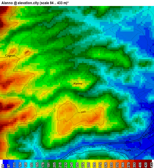
Below is the Elevation map of Alanno, which displays elevation range with different colors. Scale of the first map is from 84 to 433 m (276 to 1421 ft) with average elevation of 211.2 meters (=693 ft) [note 1]
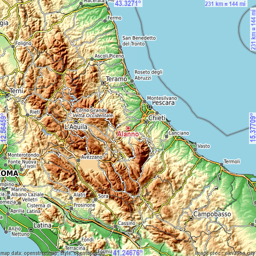
These maps also provides idea of topography and contour of this city, they are displayed at different zoom levels. More info about maps, scale and edge coordinates you can find below images.
| \ | Map #1 | Topo.Map |
| Scale [m] | 84..433 m | × |
| Scale [ft] | 276..1421 ft | × |
| Average | 211.2 m = 693 ft | × |
| Width | 7.23 km = 4.5 mi | 231.3 km = 143.7 mi |
| Height | 7.23 km = 4.5 mi | 231.3 km = 143.7 mi |
| ↑Max Latitude | 42.328017° | 43.3271° |
| Latitude at center | 42.29552° | 42.29552° |
| ↓Min Latitude | 42.263006° | 41.24676° |
| ← Min Longitude | 13.926895° | 12.56459° |
| Longitude center | 13.97084° | 13.97084° |
| →Max Longitude | 14.014785° | 15.37709° |
Nearby cities:
Cities around Alanno sort by population:
• Manoppello Scalo elevation 59 m
6.9 km,  78°
78°
• Torre de' Passeri 172 m
6.6 km,  207°
207°
• Scafa 120 m
3.9 km,  147°
147°
• San Valentino in Abruzzo Citeriore 455 m
7.1 km,  170°
170°
• Catignano 351 m
5.9 km,  344°
344°
• Rosciano 246 m
6.8 km,  64°
64°
• Nocciano 293 m
4.4 km,  16°
16°
• Civitaquana 564 m
6.7 km,  300°
300°
• Cugnoli 292 m
3.2 km,  293°
293°
• Pietranico 575 m
5.4 km,  245°
245°
• Turrivalignani 304 m
6 km,  127°
127°
• Vicoli 448 m
7.9 km,  309°
309°
Multilingual:
 En español:
Alanno elevación 285 m.
 En France:
Alanno élévation 285 m.


Sources and notes:
- [note 1] Map square and city borders are not equal. Map elevation data is calculated only from area inside that square.
- [src 1] Elevation data from geonames database provided with same terms of usage.
- [src 2] The elevation map of Alanno is generated using elevation data from NASA's 3 arcsec (90m) resolution SRTM data.
- [src 3] Base (background) map © OpenStreetMap contributors tiles are generated by Geofabrik and OpenTopoMap.
Copyright & License:
This Alanno Elevation Map is licensed under CC BY-SA. You may reuse any part from this page, if you give a proper credit by linking to this URL:
 More info on terms of use page.