Vicoli elevation
Vicoli (Abruzzo, Provincia di Pescara), Italy elevation is 448 meters and Vicoli elevation in feet is 1470 ft above sea level [src 1]. Vicoli is a seat of a third-order administrative division (feature code) with elevation that is 126 meters (413 ft) bigger than average city elevation in Italy.
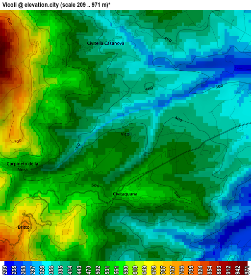
Below is the Elevation map of Vicoli, which displays elevation range with different colors. Scale of the first map is from 209 to 971 m (686 to 3186 ft) with average elevation of 461.5 meters (=1514 ft) [note 1]
These maps also provides idea of topography and contour of this city, they are displayed at different zoom levels. More info about maps, scale and edge coordinates you can find below images.
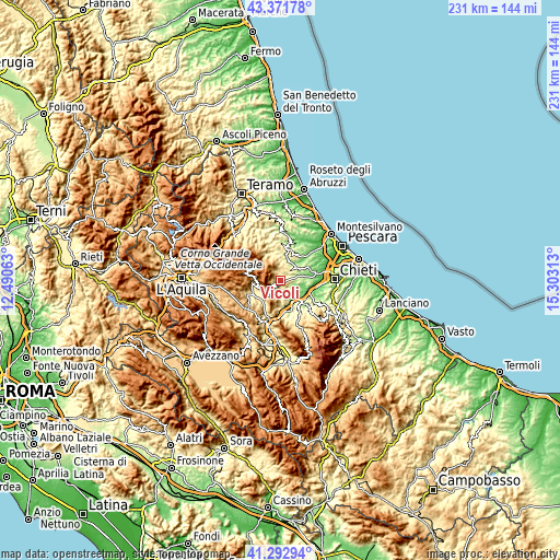
| \ | Map #1 | Topo.Map |
| Scale [m] | 209..971 m | × |
| Scale [ft] | 686..3186 ft | × |
| Average | 461.5 m = 1514 ft | × |
| Width | 7.22 km = 4.5 mi | 231.1 km = 143.6 mi |
| Height | 7.22 km = 4.5 mi | 231.1 km = 143.6 mi |
| ↑Max Latitude | 42.373424° | 43.37178° |
| Latitude at center | 42.34095° | 42.34095° |
| ↓Min Latitude | 42.308459° | 41.29294° |
| ← Min Longitude | 13.852935° | 12.49063° |
| Longitude center | 13.89688° | 13.89688° |
| →Max Longitude | 13.940825° | 15.30313° |
Nearby cities:
Cities around Vicoli sort by population:
• Alanno elevation 285 m
7.9 km,  129°
129°
• Catignano 351 m
4.6 km,  81°
81°
• Nocciano 293 m
7.3 km,  96°
96°
• Civitella Casanova 420 m
2.7 km,  339°
339°
• Civitaquana 564 m
1.7 km,  171°
171°
• Cugnoli 292 m
4.9 km,  140°
140°
• Montebello di Bertona 585 m
8.7 km,  345°
345°
• Pietranico 575 m
7.3 km, 171°
• Villa Celiera 728 m
5.5 km,  325°
325°
• Carpineto della Nora 526 m
3.1 km,  254°
254°
• Brittoli 756 m
4.2 km,  226°
226°
• Corvara 641 m
7.6 km,  194°
194°
Multilingual:
 En español:
Vicoli elevación 448 m.
 En France:
Vicoli élévation 448 m.


Sources and notes:
- [note 1] Map square and city borders are not equal. Map elevation data is calculated only from area inside that square.
- [src 1] Elevation data from geonames database provided with same terms of usage.
- [src 2] The elevation map of Vicoli is generated using elevation data from NASA's 3 arcsec (90m) resolution SRTM data.
- [src 3] Base (background) map © OpenStreetMap contributors tiles are generated by Geofabrik and OpenTopoMap.
Copyright & License:
This Vicoli Elevation Map is licensed under CC BY-SA. You may reuse any part from this page, if you give a proper credit by linking to this URL:
 More info on terms of use page.