Altare elevation
Altare (Liguria, Provincia di Savona), Italy elevation is 397 meters and Altare elevation in feet is 1302 ft above sea level [src 1]. Altare is a seat of a third-order administrative division (feature code) with elevation that is 75 meters (246 ft) bigger than average city elevation in Italy.
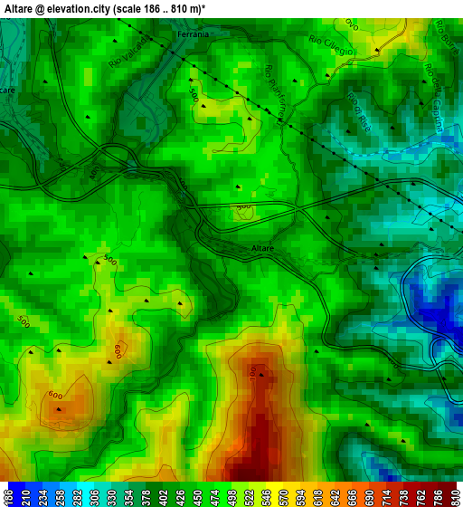
Below is the Elevation map of Altare, which displays elevation range with different colors. Scale of the first map is from 186 to 810 m (610 to 2657 ft) with average elevation of 446.7 meters (=1466 ft) [note 1]
These maps also provides idea of topography and contour of this city, they are displayed at different zoom levels. More info about maps, scale and edge coordinates you can find below images.
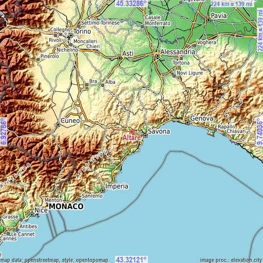
| \ | Map #1 | Topo.Map |
| Scale [m] | 186..810 m | × |
| Scale [ft] | 610..2657 ft | × |
| Average | 446.7 m = 1466 ft | × |
| Width | 6.99 km = 4.3 mi | 223.7 km = 139 mi |
| Height | 6.99 km = 4.3 mi | 223.7 km = 139 mi |
| ↑Max Latitude | 44.367084° | 45.33286° |
| Latitude at center | 44.33566° | 44.33566° |
| ↓Min Latitude | 44.304219° | 43.32121° |
| ← Min Longitude | 8.290165° | 6.92786° |
| Longitude center | 8.33411° | 8.33411° |
| →Max Longitude | 8.378055° | 9.74036° |
Nearby cities:
Cities around Altare sort by population:
• Cairo Montenotte elevation 330 m
8.2 km,  327°
327°
• Vado Ligure 11 m
10.8 km,  133°
133°
• Carcare 357 m
4.1 km,  301°
301°
• Vado Centro 9 m
10.8 km, 133°
• Valleggia 9 m
9.7 km, 128°
• Quiliano 25 m
8 km, 127°
• Valle di Vado 28 m
10.4 km,  142°
142°
• Mallare 464 m
5.9 km,  209°
209°
• Pallare 394 m
4.5 km,  258°
258°
• Bormida 586 m
10.3 km,  231°
231°
• Cosseria 530 m
8.7 km,  294°
294°
• Plodio 471 m
7.2 km, 286°
Multilingual:
 En español:
Altare elevación 397 m.
 En France:
Altare élévation 397 m.


Sources and notes:
- [note 1] Map square and city borders are not equal. Map elevation data is calculated only from area inside that square.
- [src 1] Elevation data from geonames database provided with same terms of usage.
- [src 2] The elevation map of Altare is generated using elevation data from NASA's 3 arcsec (90m) resolution SRTM data.
- [src 3] Base (background) map © OpenStreetMap contributors tiles are generated by Geofabrik and OpenTopoMap.
Copyright & License:
This Altare Elevation Map is licensed under CC BY-SA. You may reuse any part from this page, if you give a proper credit by linking to this URL:
 More info on terms of use page.