Anagni elevation
Anagni (Latium, Provincia di Frosinone), Italy elevation is 421 meters and Anagni elevation in feet is 1381 ft above sea level [src 1]. Anagni is a seat of a third-order administrative division (feature code) with elevation that is 99 meters (325 ft) bigger than average city elevation in Italy.
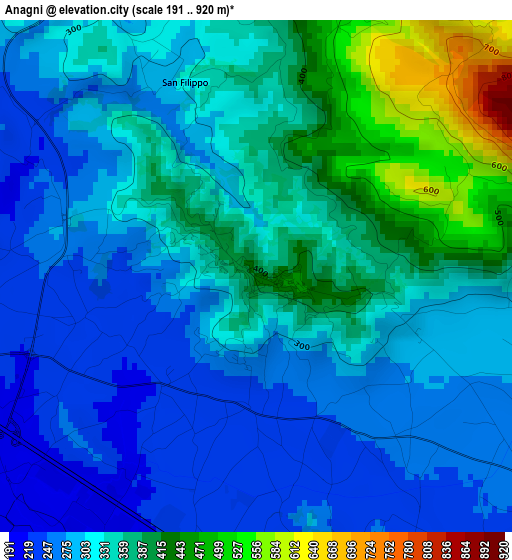
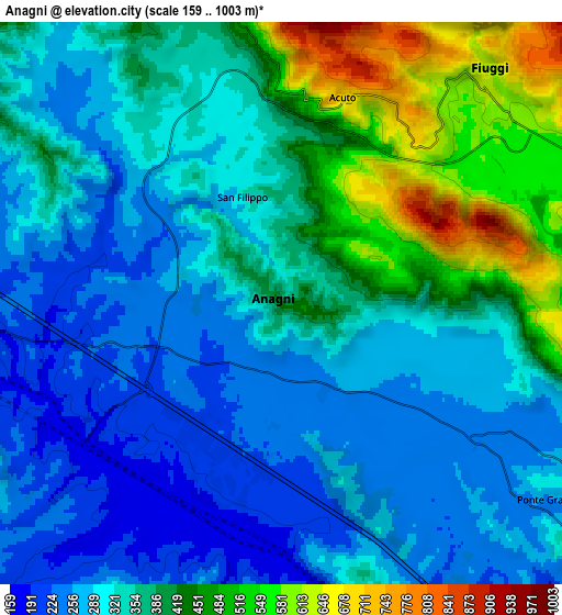
Below is the Elevation map of Anagni, which displays elevation range with different colors. Scale of the first map is from 191 to 920 m (627 to 3018 ft) with average elevation of 328 meters (=1076 ft) [note 1]
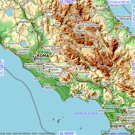
These maps also provides idea of topography and contour of this city, they are displayed at different zoom levels. More info about maps, scale and edge coordinates you can find below images.
| \ | Map #1 | Map #2 | Topo.Map |
| Scale [m] | 191..920 m | 159..1003 m | × |
| Scale [ft] | 627..3018 ft | 522..3291 ft | × |
| Average | 328 m = 1076 ft | 349.6 m = 1147 ft | × |
| Width | 7.29 km = 4.5 mi | 14.58 km = 9.1 mi | 233.3 km = 145 mi |
| Height | 7.29 km = 4.5 mi | 14.58 km = 9.1 mi | 233.3 km = 145 mi |
| ↑Max Latitude | 41.776281° | 41.809045° | 42.78417° |
| Latitude at center | 41.7435° | 41.7435° | 41.7435° |
| ↓Min Latitude | 41.710703° | 41.677888° | 40.68569° |
| ← Min Longitude | 13.111475° | 13.067529° | 11.74917° |
| Longitude center | 13.15542° | 13.15542° | 13.15542° |
| →Max Longitude | 13.199365° | 13.243311° | 14.56167° |
Nearby cities:
Cities around Anagni sort by population:
• Ferentino elevation 340 m
10.2 km,  124°
124°
• Fiuggi 643 m
8.3 km,  43°
43°
• Paliano 367 m
7.7 km,  301°
301°
• Piglio 621 m
9.8 km,  349°
349°
• Acuto 680 m
5.5 km,  16°
16°
• Sgurgola 338 m
8.3 km,  183°
183°
• Fumone 679 m
9.6 km,  95°
95°
• San Giovanni-Patoni 643 m
10.4 km,  72°
72°
• Torre Caietani 789 m
10.3 km,  62°
62°
• Gavignano 377 m
10 km,  240°
240°
• Gorga 760 m
10.7 km,  202°
202°
• Trivigliano 758 m
10.3 km, 69°
Multilingual:
 En español:
Anagni elevación 421 m.
 En France:
Anagni élévation 421 m.


Sources and notes:
- [note 1] Map square and city borders are not equal. Map elevation data is calculated only from area inside that square.
- [src 1] Elevation data from geonames database provided with same terms of usage.
- [src 2] The elevation map of Anagni is generated using elevation data from NASA's 3 arcsec (90m) resolution SRTM data.
- [src 3] Base (background) map © OpenStreetMap contributors tiles are generated by Geofabrik and OpenTopoMap.
Copyright & License:
This Anagni Elevation Map is licensed under CC BY-SA. You may reuse any part from this page, if you give a proper credit by linking to this URL:
 More info on terms of use page.