Andalo elevation
Andalo (Trentino-Alto Adige, Provincia autonoma di Trento), Italy elevation is 1024 meters and Andalo elevation in feet is 3360 ft above sea level [src 1]. Andalo is a seat of a third-order administrative division (feature code) with elevation that is 702 meters (2303 ft) bigger than average city elevation in Italy.
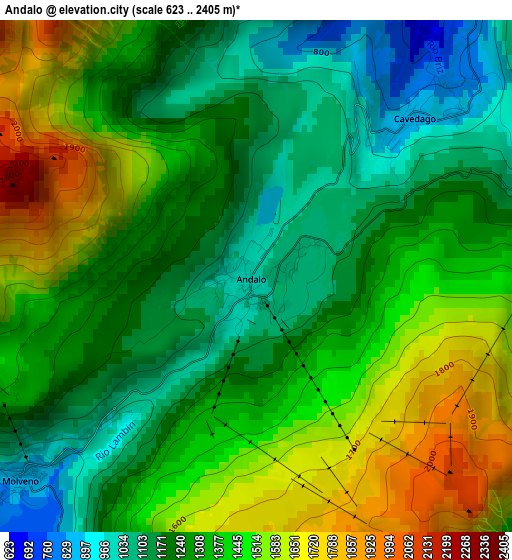
Below is the Elevation map of Andalo, which displays elevation range with different colors. Scale of the first map is from 623 to 2405 m (2044 to 7890 ft) with average elevation of 1341.8 meters (=4402 ft) [note 1]
These maps also provides idea of topography and contour of this city, they are displayed at different zoom levels. More info about maps, scale and edge coordinates you can find below images.
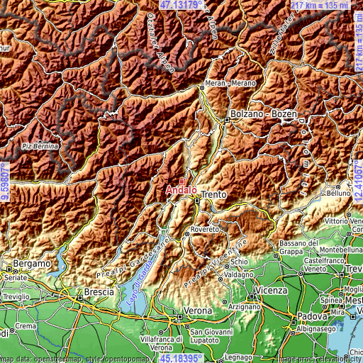
| \ | Map #1 | Topo.Map |
| Scale [m] | 623..2405 m | × |
| Scale [ft] | 2044..7890 ft | × |
| Average | 1341.8 m = 4402 ft | × |
| Width | 6.77 km = 4.2 mi | 216.6 km = 134.6 mi |
| Height | 6.77 km = 4.2 mi | 216.6 km = 134.6 mi |
| ↑Max Latitude | 46.196917° | 47.13179° |
| Latitude at center | 46.16649° | 46.16649° |
| ↓Min Latitude | 46.136047° | 45.18395° |
| ← Min Longitude | 10.960375° | 9.59807° |
| Longitude center | 11.00432° | 11.00432° |
| →Max Longitude | 11.048265° | 12.41057° |
Nearby cities:
Cities around Andalo sort by population:
• Mezzolombardo elevation 219 m
8.4 km,  57°
57°
• Lavis 229 m
8.6 km,  109°
109°
• Meano 348 m
9.9 km,  118°
118°
• Zambana 203 m
7.3 km,  103°
103°
• Vezzano 381 m
9.8 km,  183°
183°
• Spormaggiore 573 m
6.7 km,  30°
30°
• Molveno 862 m
4.2 km,  229°
229°
• Nave San Rocco 203 m
7.8 km,  88°
88°
• Fai della Paganella 975 m
5.2 km,  75°
75°
• Terlago 460 m
8.3 km,  157°
157°
• Sporminore 545 m
8.1 km,  13°
13°
• Cavedago 869 m
3 km,  47°
47°
Multilingual:
 En español:
Andalo elevación 1024 m.
 En France:
Andalo élévation 1024 m.


Sources and notes:
- [note 1] Map square and city borders are not equal. Map elevation data is calculated only from area inside that square.
- [src 1] Elevation data from geonames database provided with same terms of usage.
- [src 2] The elevation map of Andalo is generated using elevation data from NASA's 3 arcsec (90m) resolution SRTM data.
- [src 3] Base (background) map © OpenStreetMap contributors tiles are generated by Geofabrik and OpenTopoMap.
Copyright & License:
This Andalo Elevation Map is licensed under CC BY-SA. You may reuse any part from this page, if you give a proper credit by linking to this URL:
 More info on terms of use page.