Fai della Paganella elevation
Fai della Paganella (Trentino-Alto Adige, Provincia autonoma di Trento), Italy elevation is 975 meters and Fai della Paganella elevation in feet is 3199 ft above sea level [src 1]. Fai della Paganella is a seat of a third-order administrative division (feature code) with elevation that is 653 meters (2142 ft) bigger than average city elevation in Italy.
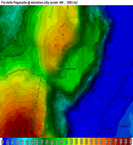
Below is the Elevation map of Fai della Paganella, which displays elevation range with different colors. Scale of the first map is from 160 to 1993 m (525 to 6539 ft) with average elevation of 797.4 meters (=2616 ft) [note 1]
These maps also provides idea of topography and contour of this city, they are displayed at different zoom levels. More info about maps, scale and edge coordinates you can find below images.
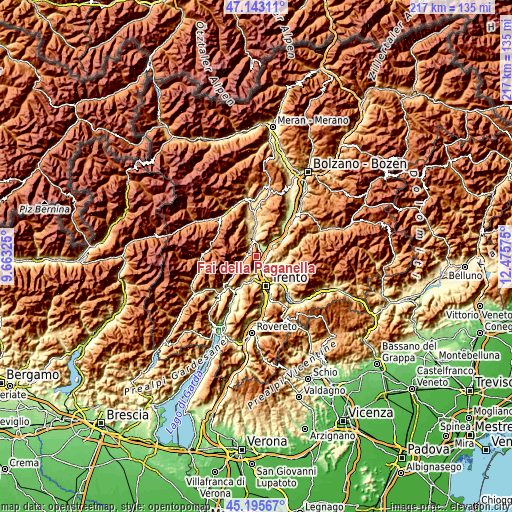
| \ | Map #1 | Topo.Map |
| Scale [m] | 160..1993 m | × |
| Scale [ft] | 525..6539 ft | × |
| Average | 797.4 m = 2616 ft | × |
| Width | 6.77 km = 4.2 mi | 216.5 km = 134.5 mi |
| Height | 6.77 km = 4.2 mi | 216.5 km = 134.5 mi |
| ↑Max Latitude | 46.20843° | 47.14311° |
| Latitude at center | 46.17801° | 46.17801° |
| ↓Min Latitude | 46.147573° | 45.19567° |
| ← Min Longitude | 11.025555° | 9.66325° |
| Longitude center | 11.0695° | 11.0695° |
| →Max Longitude | 11.113445° | 12.47575° |
Nearby cities:
Cities around Fai della Paganella sort by population:
• Mezzolombardo elevation 219 m
3.9 km,  32°
32°
• Lavis 229 m
5.1 km,  143°
143°
• Mezzocorona 212 m
5.5 km,  47°
47°
• San Michele All'Adige 202 m
5 km,  74°
74°
• Giovo 497 m
6.9 km,  111°
111°
• Meano 348 m
7 km,  148°
148°
• Zambana 203 m
3.6 km, 144°
• Spormaggiore 573 m
4.8 km,  339°
339°
• Nave San Rocco 203 m
3 km, 112°
• Andalo 1024 m
5.2 km,  255°
255°
• Verla 515 m
6.8 km, 109°
• Cavedago 869 m
2.9 km,  285°
285°
Multilingual:
 En español:
Fai della Paganella elevación 975 m.
 En France:
Fai della Paganella élévation 975 m.
 Auf Deutsch:
Fai della Paganella höhe über dem Meeresspiegel ist 975 m.
 На русском:
Fai della Paganella высота над уровнем моря 975 м
Sources and notes:
- [note 1] Map square and city borders are not equal. Map elevation data is calculated only from area inside that square.
- [src 1] Elevation data from geonames database provided with same terms of usage.
- [src 2] The elevation map of Fai della Paganella is generated using elevation data from NASA's 3 arcsec (90m) resolution SRTM data.
- [src 3] Base (background) map © OpenStreetMap contributors tiles are generated by Geofabrik and OpenTopoMap.
Copyright & License:
This Fai della Paganella Elevation Map is licensed under CC BY-SA. You may reuse any part from this page, if you give a proper credit by linking to this URL:
 More info on terms of use page.