Andretta-Mattinella elevation
Andretta-Mattinella (Campania, Provincia di Avellino), Italy elevation is 806 meters and Andretta-Mattinella elevation in feet is 2644 ft above sea level [src 1]. Andretta-Mattinella is a seat of a third-order administrative division (feature code) with elevation that is 484 meters (1588 ft) bigger than average city elevation in Italy.
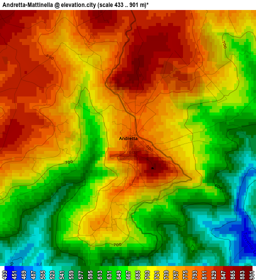
Below is the Elevation map of Andretta-Mattinella, which displays elevation range with different colors. Scale of the first map is from 433 to 901 m (1421 to 2956 ft) with average elevation of 709.1 meters (=2326 ft) [note 1]
These maps also provides idea of topography and contour of this city, they are displayed at different zoom levels. More info about maps, scale and edge coordinates you can find below images.
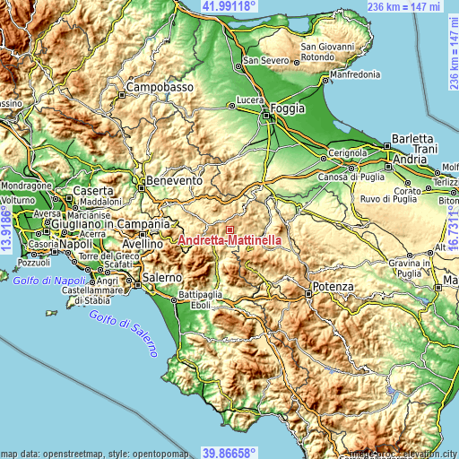
| \ | Map #1 | Topo.Map |
| Scale [m] | 433..901 m | × |
| Scale [ft] | 1421..2956 ft | × |
| Average | 709.1 m = 2326 ft | × |
| Width | 7.38 km = 4.6 mi | 236.2 km = 146.8 mi |
| Height | 7.38 km = 4.6 mi | 236.2 km = 146.8 mi |
| ↑Max Latitude | 40.970609° | 41.99118° |
| Latitude at center | 40.93742° | 40.93742° |
| ↓Min Latitude | 40.904214° | 39.86658° |
| ← Min Longitude | 15.280905° | 13.9186° |
| Longitude center | 15.32485° | 15.32485° |
| →Max Longitude | 15.368795° | 16.7311° |
Nearby cities:
Cities around Andretta-Mattinella sort by population:
• Calitri elevation 692 m
6.8 km,  101°
101°
• Sant'Angelo dei Lombardi 836 m
12.6 km,  265°
265°
• Pescopagano 947 m
13 km,  151°
151°
• Bisaccia Nuova 874 m
8.4 km,  17°
17°
• Vallata 851 m
12.9 km,  332°
332°
• Sant'Andrea di Conza 661 m
11 km,  159°
159°
• Teora 654 m
11.2 km,  212°
212°
• Bisaccia 898 m
9.1 km,  28°
28°
• Nuova Conza della Campania 486 m
8.8 km,  173°
173°
• Morra de Sanctis 835 m
7 km,  262°
262°
• Guardia Lombardi 999 m
9.9 km,  279°
279°
• Cairano 745 m
6 km,  140°
140°
Multilingual:
 En español:
Andretta-Mattinella elevación 806 m.
 En France:
Andretta élévation 806 m.
 Auf Deutsch:
Andretta-Mattinella höhe über dem Meeresspiegel ist 806 m.
 На русском:
Andretta-Mattinella высота над уровнем моря 806 м
Sources and notes:
- [note 1] Map square and city borders are not equal. Map elevation data is calculated only from area inside that square.
- [src 1] Elevation data from geonames database provided with same terms of usage.
- [src 2] The elevation map of Andretta-Mattinella is generated using elevation data from NASA's 3 arcsec (90m) resolution SRTM data.
- [src 3] Base (background) map © OpenStreetMap contributors tiles are generated by Geofabrik and OpenTopoMap.
Copyright & License:
This Andretta-Mattinella Elevation Map is licensed under CC BY-SA. You may reuse any part from this page, if you give a proper credit by linking to this URL:
 More info on terms of use page.