Arnara elevation
Arnara (Latium, Provincia di Frosinone), Italy elevation is 262 meters and Arnara elevation in feet is 860 ft above sea level [src 1]. Arnara is a seat of a third-order administrative division (feature code) with elevation that is 60 meters (197 ft) smaller than average city elevation in Italy.
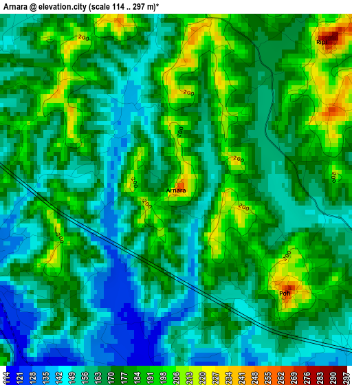
Below is the Elevation map of Arnara, which displays elevation range with different colors. Scale of the first map is from 114 to 297 m (374 to 974 ft) with average elevation of 171.7 meters (=563 ft) [note 1]
These maps also provides idea of topography and contour of this city, they are displayed at different zoom levels. More info about maps, scale and edge coordinates you can find below images.
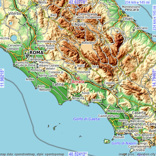
| \ | Map #1 | Topo.Map |
| Scale [m] | 114..297 m | × |
| Scale [ft] | 374..974 ft | × |
| Average | 171.7 m = 563 ft | × |
| Width | 7.31 km = 4.5 mi | 233.9 km = 145.3 mi |
| Height | 7.31 km = 4.5 mi | 233.9 km = 145.3 mi |
| ↑Max Latitude | 41.617382° | 42.62778° |
| Latitude at center | 41.58452° | 41.58452° |
| ↓Min Latitude | 41.551642° | 40.52412° |
| ← Min Longitude | 13.344455° | 11.98215° |
| Longitude center | 13.3884° | 13.3884° |
| →Max Longitude | 13.432345° | 14.79465° |
Nearby cities:
Cities around Arnara sort by population:
• Frosinone elevation 183 m
7.3 km,  327°
327°
• Ceccano 223 m
5.1 km,  254°
254°
• Sant'Angelo in Villa-Giglio 303 m
9.3 km,  21°
21°
• Colle Campano-Scrima 242 m
7.6 km,  55°
55°
• Ripi 265 m
4.4 km,  42°
42°
• Castelmassimo 234 m
8.8 km,  355°
355°
• Boville Ernica 494 m
9.5 km,  47°
47°
• Torrice 287 m
5.6 km,  13°
13°
• Pofi 266 m
3 km,  134°
134°
• Strangolagalli 211 m
8.8 km,  78°
78°
• Villa Santo Stefano 217 m
9.9 km,  220°
220°
• Castro dei Volsci 360 m
8.6 km,  170°
170°
Multilingual:
 En español:
Arnara elevación 262 m.
 En France:
Arnara élévation 262 m.


Sources and notes:
- [note 1] Map square and city borders are not equal. Map elevation data is calculated only from area inside that square.
- [src 1] Elevation data from geonames database provided with same terms of usage.
- [src 2] The elevation map of Arnara is generated using elevation data from NASA's 3 arcsec (90m) resolution SRTM data.
- [src 3] Base (background) map © OpenStreetMap contributors tiles are generated by Geofabrik and OpenTopoMap.
Copyright & License:
This Arnara Elevation Map is licensed under CC BY-SA. You may reuse any part from this page, if you give a proper credit by linking to this URL:
 More info on terms of use page.