Ripi elevation
Ripi (Latium, Provincia di Frosinone), Italy elevation is 265 meters and Ripi elevation in feet is 869 ft above sea level [src 1]. Ripi is a seat of a third-order administrative division (feature code) with elevation that is 57 meters (187 ft) smaller than average city elevation in Italy.
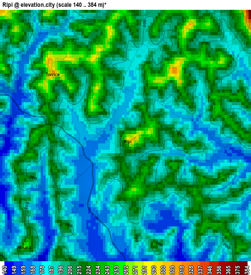
Below is the Elevation map of Ripi, which displays elevation range with different colors. Scale of the first map is from 140 to 384 m (459 to 1260 ft) with average elevation of 199.5 meters (=655 ft) [note 1]
These maps also provides idea of topography and contour of this city, they are displayed at different zoom levels. More info about maps, scale and edge coordinates you can find below images.
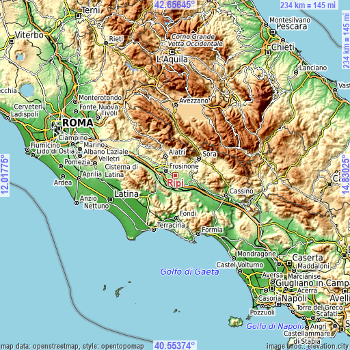
| \ | Map #1 | Topo.Map |
| Scale [m] | 140..384 m | × |
| Scale [ft] | 459..1260 ft | × |
| Average | 199.5 m = 655 ft | × |
| Width | 7.31 km = 4.5 mi | 233.8 km = 145.3 mi |
| Height | 7.31 km = 4.5 mi | 233.8 km = 145.3 mi |
| ↑Max Latitude | 41.646507° | 42.65645° |
| Latitude at center | 41.61366° | 41.61366° |
| ↓Min Latitude | 41.580796° | 40.55374° |
| ← Min Longitude | 13.380055° | 12.01775° |
| Longitude center | 13.424° | 13.424° |
| →Max Longitude | 13.467945° | 14.83025° |
Nearby cities:
Cities around Ripi sort by population:
• Frosinone elevation 183 m
7.5 km,  292°
292°
• Sant'Angelo in Villa-Giglio 303 m
5.4 km,  4°
4°
• Colle Campano-Scrima 242 m
3.5 km,  71°
71°
• San Giuseppe le Prata-Cotropagno 239 m
7.5 km,  342°
342°
• Case Campoli-Panetta 330 m
7.7 km,  31°
31°
• Castelmassimo 234 m
6.6 km,  327°
327°
• Boville Ernica 494 m
5.2 km,  51°
51°
• Torrice 287 m
2.8 km,  322°
322°
• Pofi 266 m
5.4 km,  188°
188°
• Monte San Giovanni Campano 405 m
7.9 km, 65°
• Strangolagalli 211 m
5.9 km,  105°
105°
• Arnara 262 m
4.4 km,  222°
222°
Multilingual:
 En español:
Ripi elevación 265 m.
 En France:
Ripi élévation 265 m.


Sources and notes:
- [note 1] Map square and city borders are not equal. Map elevation data is calculated only from area inside that square.
- [src 1] Elevation data from geonames database provided with same terms of usage.
- [src 2] The elevation map of Ripi is generated using elevation data from NASA's 3 arcsec (90m) resolution SRTM data.
- [src 3] Base (background) map © OpenStreetMap contributors tiles are generated by Geofabrik and OpenTopoMap.
Copyright & License:
This Ripi Elevation Map is licensed under CC BY-SA. You may reuse any part from this page, if you give a proper credit by linking to this URL:
 More info on terms of use page.