Ascea elevation
Ascea (Campania, Provincia di Salerno), Italy elevation is 231 meters and Ascea elevation in feet is 758 ft above sea level [src 1]. Ascea is a seat of a third-order administrative division (feature code) with elevation that is 91 meters (299 ft) smaller than average city elevation in Italy.
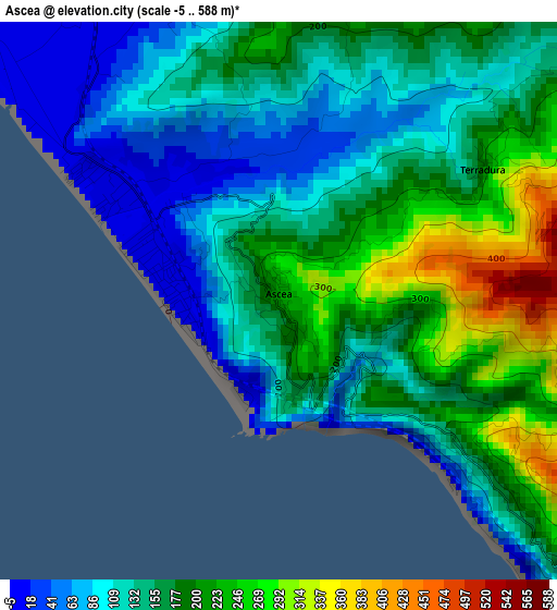
Below is the Elevation map of Ascea, which displays elevation range with different colors. Scale of the first map is from -5 to 588 m (-16 to 1929 ft) with average elevation of 157.7 meters (=517 ft) [note 1]
These maps also provides idea of topography and contour of this city, they are displayed at different zoom levels. More info about maps, scale and edge coordinates you can find below images.
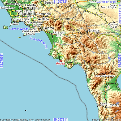
| \ | Map #1 | Topo.Map |
| Scale [m] | -5..588 m | × |
| Scale [ft] | -16..1929 ft | × |
| Average | 157.7 m = 517 ft | × |
| Width | 7.47 km = 4.6 mi | 239.1 km = 148.6 mi |
| Height | 7.47 km = 4.6 mi | 239.1 km = 148.6 mi |
| ↑Max Latitude | 40.174406° | 41.20732° |
| Latitude at center | 40.14082° | 40.14082° |
| ↓Min Latitude | 40.107217° | 39.05731° |
| ← Min Longitude | 15.141885° | 13.77958° |
| Longitude center | 15.18583° | 15.18583° |
| →Max Longitude | 15.229775° | 16.59208° |
Nearby cities:
Cities around Ascea sort by population:
• Vallo della Lucania elevation 400 m
11.9 km,  35°
35°
• Novi Velia 578 m
12.5 km, 43°
• Marina di Casal Velino 4 m
6.7 km,  306°
306°
• Futani 445 m
11.8 km,  84°
84°
• Salento 419 m
12 km,  1°
1°
• Pisciotta 192 m
5.5 km,  130°
130°
• Casal Velino 142 m
8.4 km, 311°
• Ceraso 330 m
8.4 km,  45°
45°
• Cuccaro Vetere 629 m
10.6 km, 75°
• San Mauro la Bruca 426 m
9.2 km,  102°
102°
• Pollica 374 m
12.3 km,  296°
296°
• Castelnuovo Cilento 264 m
8.7 km,  355°
355°
Multilingual:
 En español:
Ascea elevación 231 m.
 En France:
Ascea élévation 231 m.


Sources and notes:
- [note 1] Map square and city borders are not equal. Map elevation data is calculated only from area inside that square.
- [src 1] Elevation data from geonames database provided with same terms of usage.
- [src 2] The elevation map of Ascea is generated using elevation data from NASA's 3 arcsec (90m) resolution SRTM data.
- [src 3] Base (background) map © OpenStreetMap contributors tiles are generated by Geofabrik and OpenTopoMap.
Copyright & License:
This Ascea Elevation Map is licensed under CC BY-SA. You may reuse any part from this page, if you give a proper credit by linking to this URL:
 More info on terms of use page.