Salento elevation
Salento (Campania, Provincia di Salerno), Italy elevation is 419 meters and Salento elevation in feet is 1375 ft above sea level [src 1]. Salento is a seat of a third-order administrative division (feature code) with elevation that is 97 meters (318 ft) bigger than average city elevation in Italy.
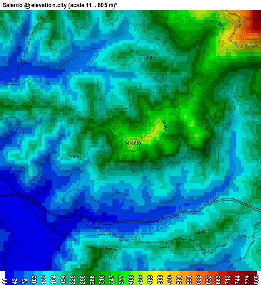
Below is the Elevation map of Salento, which displays elevation range with different colors. Scale of the first map is from 11 to 805 m (36 to 2641 ft) with average elevation of 181.5 meters (=595 ft) [note 1]
These maps also provides idea of topography and contour of this city, they are displayed at different zoom levels. More info about maps, scale and edge coordinates you can find below images.
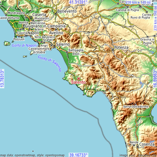
| \ | Map #1 | Topo.Map |
| Scale [m] | 11..805 m | × |
| Scale [ft] | 36..2641 ft | × |
| Average | 181.5 m = 595 ft | × |
| Width | 7.46 km = 4.6 mi | 238.7 km = 148.3 mi |
| Height | 7.46 km = 4.6 mi | 238.7 km = 148.3 mi |
| ↑Max Latitude | 40.282663° | 41.31391° |
| Latitude at center | 40.24913° | 40.24913° |
| ↓Min Latitude | 40.215581° | 39.16733° |
| ← Min Longitude | 15.145435° | 13.78313° |
| Longitude center | 15.18938° | 15.18938° |
| →Max Longitude | 15.233325° | 16.59563° |
Nearby cities:
Cities around Salento sort by population:
• Vallo della Lucania elevation 400 m
6.9 km,  109°
109°
• Novi Velia 578 m
8.7 km, 109°
• Moio della Civitella-Pellare 536 m
6.7 km,  91°
91°
• Cannalonga 547 m
8.8 km, 93°
• Gioi 688 m
5.1 km,  28°
28°
• Orria 536 m
5.8 km,  344°
344°
• Ceraso 330 m
8.3 km,  137°
137°
• Stio 677 m
8.6 km,  37°
37°
• Perito 460 m
6.5 km,  327°
327°
• Omignano 543 m
8.9 km,  270°
270°
• Stella Cilento 394 m
8.4 km,  256°
256°
• Castelnuovo Cilento 264 m
3.5 km,  195°
195°
Multilingual:
 En español:
Salento elevación 419 m.
 En France:
Salento élévation 419 m.


Sources and notes:
- [note 1] Map square and city borders are not equal. Map elevation data is calculated only from area inside that square.
- [src 1] Elevation data from geonames database provided with same terms of usage.
- [src 2] The elevation map of Salento is generated using elevation data from NASA's 3 arcsec (90m) resolution SRTM data.
- [src 3] Base (background) map © OpenStreetMap contributors tiles are generated by Geofabrik and OpenTopoMap.
Copyright & License:
This Salento Elevation Map is licensed under CC BY-SA. You may reuse any part from this page, if you give a proper credit by linking to this URL:
 More info on terms of use page.