Asola elevation
Asola (Lombardy, Provincia di Mantova), Italy elevation is 37 meters and Asola elevation in feet is 121 ft above sea level [src 1]. Asola is a seat of a third-order administrative division (feature code) with elevation that is 285 meters (935 ft) smaller than average city elevation in Italy.
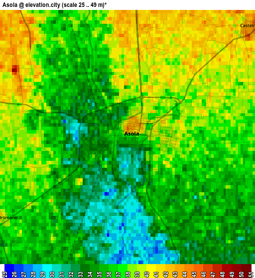
Below is the Elevation map of Asola, which displays elevation range with different colors. Scale of the first map is from 25 to 49 m (82 to 161 ft) with average elevation of 36.3 meters (=119 ft) [note 1]
These maps also provides idea of topography and contour of this city, they are displayed at different zoom levels. More info about maps, scale and edge coordinates you can find below images.
| \ | Map #1 | Map #2 | Topo.Map |
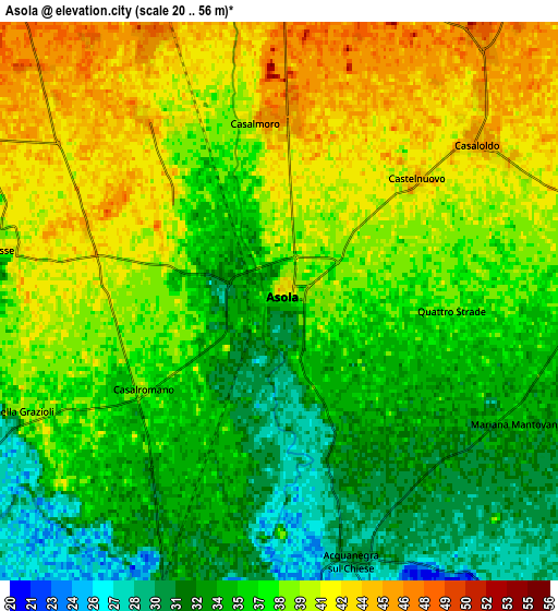
| Scale [m] | 25..49 m | 20..56 m | × |
| Scale [ft] | 82..161 ft | 66..184 ft | × |
| Average | 36.3 m = 119 ft | 37.2 m = 122 ft | × |
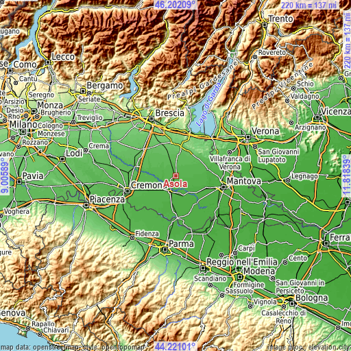
| Width | 6.88 km = 4.3 mi | 13.77 km = 8.6 mi | 220.3 km = 136.9 mi |
| Height | 6.88 km = 4.3 mi | 13.77 km = 8.6 mi | 220.3 km = 136.9 mi |
| ↑Max Latitude | 45.251126° | 45.282055° | 46.20209° |
| Latitude at center | 45.22018° | 45.22018° | 45.22018° |
| ↓Min Latitude | 45.189217° | 45.158238° | 44.22101° |
| ← Min Longitude | 10.368195° | 10.324249° | 9.00589° |
| Longitude center | 10.41214° | 10.41214° | 10.41214° |
| →Max Longitude | 10.456085° | 10.500031° | 11.81839° |
Nearby cities:
Cities around Asola sort by population:
• Castel Goffredo elevation 51 m
9.5 km,  30°
30°
• Canneto sull'Oglio 31 m
8 km,  196°
196°
• Remedello 49 m
7.2 km,  334°
334°
• Remedello di Sopra 47 m
7.3 km, 333°
• Acquanegra sul Chiese 29 m
6.5 km,  165°
165°
• Casaloldo 47 m
6.3 km,  53°
53°
• Casalmoro 47 m
4.6 km,  359°
359°
• Fiesse 41 m
7 km,  280°
280°
• Casalromano 37 m
4.3 km,  235°
235°
• Piubega 40 m
9.4 km,  85°
85°
• Mariana Mantovana 34 m
6.6 km,  117°
117°
• Volongo 44 m
8.6 km,  263°
263°
Multilingual:
 En español:
Asola elevación 37 m.
 En France:
Asola élévation 37 m.


Sources and notes:
- [note 1] Map square and city borders are not equal. Map elevation data is calculated only from area inside that square.
- [src 1] Elevation data from geonames database provided with same terms of usage.
- [src 2] The elevation map of Asola is generated using elevation data from NASA's 3 arcsec (90m) resolution SRTM data.
- [src 3] Base (background) map © OpenStreetMap contributors tiles are generated by Geofabrik and OpenTopoMap.
Copyright & License:
This Asola Elevation Map is licensed under CC BY-SA. You may reuse any part from this page, if you give a proper credit by linking to this URL:
 More info on terms of use page.