Asti elevation
Asti (Piedmont, Provincia di Asti), Italy elevation is 132 meters and Asti elevation in feet is 433 ft above sea level [src 1]. Asti is a seat of a second-order administrative division (feature code) with elevation that is 190 meters (623 ft) smaller than average city elevation in Italy.
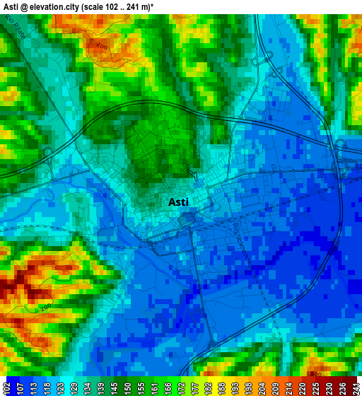
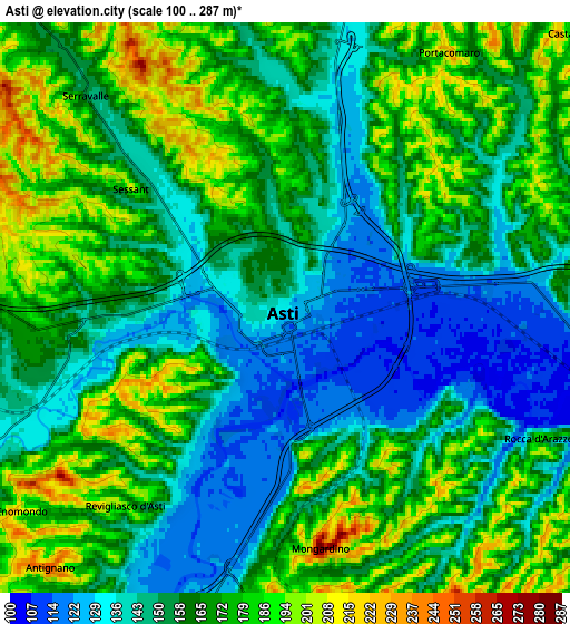
Below is the Elevation map of Asti, which displays elevation range with different colors. Scale of the first map is from 102 to 241 m (335 to 791 ft) with average elevation of 138.4 meters (=454 ft) [note 1]
These maps also provides idea of topography and contour of this city, they are displayed at different zoom levels. More info about maps, scale and edge coordinates you can find below images.
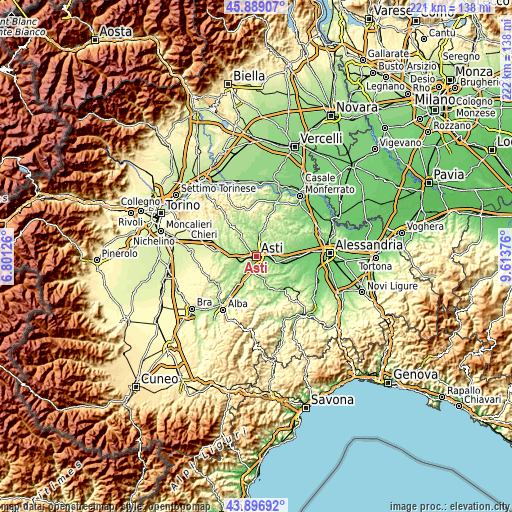
| \ | Map #1 | Map #2 | Topo.Map |
| Scale [m] | 102..241 m | 100..287 m | × |
| Scale [ft] | 335..791 ft | 328..942 ft | × |
| Average | 138.4 m = 454 ft | 161.7 m = 531 ft | × |
| Width | 6.92 km = 4.3 mi | 13.84 km = 8.6 mi | 221.5 km = 137.6 mi |
| Height | 6.92 km = 4.3 mi | 13.84 km = 8.6 mi | 221.5 km = 137.6 mi |
| ↑Max Latitude | 44.932739° | 44.963841° | 45.88907° |
| Latitude at center | 44.90162° | 44.90162° | 44.90162° |
| ↓Min Latitude | 44.870484° | 44.839332° | 43.89692° |
| ← Min Longitude | 8.163565° | 8.119619° | 6.80126° |
| Longitude center | 8.20751° | 8.20751° | 8.20751° |
| →Max Longitude | 8.251455° | 8.295401° | 9.61376° |
Nearby cities:
Cities around Asti sort by population:
• Isola d'Asti elevation 126 m
7.9 km,  195°
195°
• Piano-Molini d'Isola 144 m
8 km, 195°
• Portacomaro 226 m
7.3 km,  33°
33°
• Revigliasco d'Asti 192 m
6.1 km,  217°
217°
• Mongardino 284 m
5.9 km,  171°
171°
• Antignano 257 m
8.5 km, 222°
• Scurzolengo 233 m
9 km,  38°
38°
• Montaldo Scarampi 271 m
8.9 km,  152°
152°
• Celle Enomondo 223 m
8.3 km,  232°
232°
• Azzano d'Asti 182 m
5.6 km,  123°
123°
• Rocca d'Arazzo 182 m
6.9 km, 118°
• Vigliano d'Asti 245 m
7.7 km, 167°
Multilingual:
 En español:
Asti elevación 132 m.
 En France:
Asti élévation 132 m.


Sources and notes:
- [note 1] Map square and city borders are not equal. Map elevation data is calculated only from area inside that square.
- [src 1] Elevation data from geonames database provided with same terms of usage.
- [src 2] The elevation map of Asti is generated using elevation data from NASA's 3 arcsec (90m) resolution SRTM data.
- [src 3] Base (background) map © OpenStreetMap contributors tiles are generated by Geofabrik and OpenTopoMap.
Copyright & License:
This Asti Elevation Map is licensed under CC BY-SA. You may reuse any part from this page, if you give a proper credit by linking to this URL:
 More info on terms of use page.