Aurelia elevation
Aurelia (Latium, Città metropolitana di Roma Capitale), Italy elevation is 65 meters and Aurelia elevation in feet is 213 ft above sea level [src 1]. Aurelia is a populated place (feature code) with elevation that is 257 meters (843 ft) smaller than average city elevation in Italy.
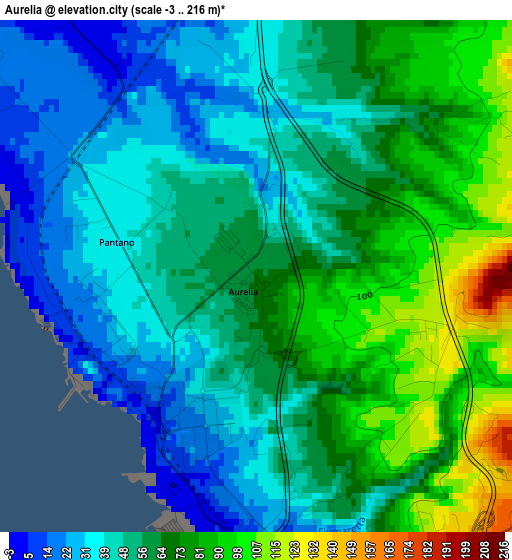
Below is the Elevation map of Aurelia, which displays elevation range with different colors. Scale of the first map is from -3 to 216 m (-10 to 709 ft) with average elevation of 58.6 meters (=192 ft) [note 1]
These maps also provides idea of topography and contour of this city, they are displayed at different zoom levels. More info about maps, scale and edge coordinates you can find below images.
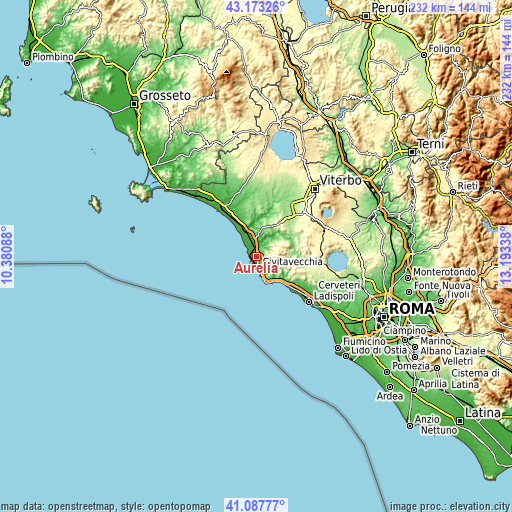
| \ | Map #1 | Topo.Map |
| Scale [m] | -3..216 m | × |
| Scale [ft] | -10..709 ft | × |
| Average | 58.6 m = 192 ft | × |
| Width | 7.25 km = 4.5 mi | 231.9 km = 144.1 mi |
| Height | 7.25 km = 4.5 mi | 231.9 km = 144.1 mi |
| ↑Max Latitude | 42.171678° | 43.17326° |
| Latitude at center | 42.1391° | 42.1391° |
| ↓Min Latitude | 42.106505° | 41.08777° |
| ← Min Longitude | 11.743185° | 10.38088° |
| Longitude center | 11.78713° | 11.78713° |
| →Max Longitude | 11.831075° | 13.19338° |
Nearby cities:
Cities around Aurelia sort by population:
• Civitavecchia elevation 22 m
5.2 km,  171°
171°
• Santa Marinella 11 m
12.9 km,  154°
154°
• Tarquinia 128 m
13 km,  348°
348°
• Montalto di Castro 38 m
27.7 km,  327°
327°
• Tolfa 509 m
12 km,  84°
84°
• Allumiere 522 m
9.8 km, 77°
• Blera 287 m
24.9 km,  53°
53°
• Canale Monterano 380 m
26 km,  90°
90°
• Monte Romano 229 m
16.9 km,  32°
32°
• Vejano 399 m
26.8 km,  70°
70°
• Villa San Giovanni in Tuscia 333 m
26.9 km, 54°
• Barbarano Romano 341 m
26.2 km,  62°
62°
Multilingual:
 En español:
Aurelia elevación 65 m.
 En France:
Aurelia élévation 65 m.


Sources and notes:
- [note 1] Map square and city borders are not equal. Map elevation data is calculated only from area inside that square.
- [src 1] Elevation data from geonames database provided with same terms of usage.
- [src 2] The elevation map of Aurelia is generated using elevation data from NASA's 3 arcsec (90m) resolution SRTM data.
- [src 3] Base (background) map © OpenStreetMap contributors tiles are generated by Geofabrik and OpenTopoMap.
Copyright & License:
This Aurelia Elevation Map is licensed under CC BY-SA. You may reuse any part from this page, if you give a proper credit by linking to this URL:
 More info on terms of use page.